IMAGES TAKEN NEAR TO
Antrobus Road, SUTTON COLDFIELD, B73 5EN
Introduction
This page details the photographs taken nearby to Antrobus Road, B73 5EN by members of the Geograph project.
The Geograph project started in 2005 with the aim of publishing, organising and preserving representative images for every square kilometre of Great Britain, Ireland and the Isle of Man.

There are currently over 7.5m images from over14,400 individuals and you can help contribute to the project by visiting https://www.geograph.org.uk
Image Map
Images are licensed for reuse under creativecommons.org/licenses/by-sa/2.0
Notes
- Clicking on the map will re-center to the selected point.
- The higher the marker number, the further away the image location is from the centre of the postcode.
Image Listing (17 Images Found)
Images are licensed for reuse under creativecommons.org/licenses/by-sa/2.0
Image
Details
Distance

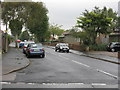
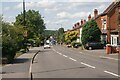
3
Whose Speed?
There wasn't a car within sight either way on Boldmere Road, but this sign continued to display figures at random.
Image: © Peter Whatley
Taken: 22 Sep 2008
0.14 miles
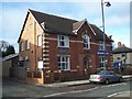
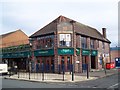
5

Shops, Boldmere Road B4142
A wide range of shops and services makes for a lively street scene here at the north end of Boldmere Road.
Image: © Robin Stott
Taken: 17 May 2011
0.15 miles
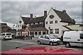
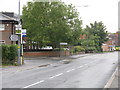
9
Boldmere Road
Further along this straight road is a collection of shops and food and drink outlets. The trees in the distance are in Sutton Park.
Image: © Bill Boaden
Taken: 29 Jun 2023
0.18 miles