IMAGES TAKEN NEAR TO
Chester Road, SUTTON COLDFIELD, B73 5BZ
Introduction
This page details the photographs taken nearby to Chester Road, B73 5BZ by members of the Geograph project.
The Geograph project started in 2005 with the aim of publishing, organising and preserving representative images for every square kilometre of Great Britain, Ireland and the Isle of Man.

There are currently over 7.5m images from over14,400 individuals and you can help contribute to the project by visiting https://www.geograph.org.uk
Image Map
Images are licensed for reuse under creativecommons.org/licenses/by-sa/2.0
Notes
- Clicking on the map will re-center to the selected point.
- The higher the marker number, the further away the image location is from the centre of the postcode.
Image Listing (15 Images Found)
Images are licensed for reuse under creativecommons.org/licenses/by-sa/2.0
Image
Details
Distance
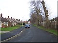
1
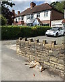
Dead fox by Chester Road, Sutton Coldfield
These houses have long rear gardens that back on to other long rear gardens: plenty of living space for foxes.
Image: © Robin Stott
Taken: 13 Jul 2021
0.02 miles
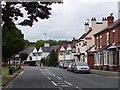
2
Former lodge to Fernwood Grange, Fernwood Road, Sutton Coldfield
The building, now a private dwelling, is at the corner of Fernwood Road and Chester Road. The latter must be the street address given the 3-digit number on the front door. There is an excellent article about Fernwood Grange here: https://sclhrg.org.uk/history-spot/104-articles-121-160/1992-fernwood-148.html
Image: © Robin Stott
Taken: 13 Jul 2021
0.04 miles
3
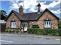
Former lodge to Fernwood Grange, Fernwood Road, Sutton Coldfield
The building, now a private dwelling, is at the corner of Fernwood Road and Chester Road. The latter must be the street address given the 3-digit number on the front door. There is an excellent article about Fernwood Grange here: https://sclhrg.org.uk/history-spot/104-articles-121-160/1992-fernwood-148.html
Image: © Robin Stott
Taken: 13 Jul 2021
0.04 miles
4
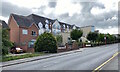
New Oscott Village, Chester Road, Sutton Coldfield
Retirement apartments are for sale.
[Crazy sky – due to some accidental setting on the phone.]
Image: © Robin Stott
Taken: 13 Jul 2021
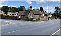
0.06 miles
6
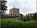
Failure
Fosseway Drive, B23, viewed from the car park of The Greyhound. Built on the edge of Sutton Coldfield, around the time it became part of Birmingham, the blocks lie empty awaiting demolition. Well, I thought they were empty, but I've now discovered there are a few people still living there...
Image: © Adrian Bailey
Taken: 17 Jun 2005
0.15 miles
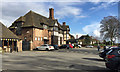
8
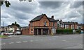
Closed corner shop, Boldmere
The property, on the corner of Chester Road (A452) and Beech Road, left, is occupied but the corner shop appears to have been closed for some time. The street nameplate for Beech Road is a cast-iron type from an earlier age. A map from between 1888 and 1913 shows that this section of 'Old Chester Road' was relatively undeveloped; there was an isolated property on this corner. The view is across Chester Road from the corner of Church Road.
Photo number 7843038.
Image: © Robin Stott
Taken: 8 Jul 2024
0.17 miles
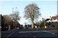
9
Court Lane
Looking north, at the point where the road leaves Birmingham and enters Sutton.
Image: © Adrian Bailey
Taken: 17 Jun 2005
0.20 miles
10
Garden centre coffee shop, Chester Road, north Birmingham
A branch of Hall's Garden Centre https://www.hallsgardencentre.com/about-halls-garden-centre Sited on the corner of busy Chester Road and Antrobus Road, the coffee shop seems to be the destination while the garden centre to the rear is almost an add-on, notwithstanding the variety and quality of the goods. The building is a former pub, first shown on a map of 1937; on maps of the 1960s and 70s it's labelled New Oscott Tavern.
Image: © Robin Stott
Taken: 16 Mar 2018
0.21 miles