IMAGES TAKEN NEAR TO
Winchester Road, WEST BROMWICH, B71 2NY
Introduction
This page details the photographs taken nearby to Winchester Road, B71 2NY by members of the Geograph project.
The Geograph project started in 2005 with the aim of publishing, organising and preserving representative images for every square kilometre of Great Britain, Ireland and the Isle of Man.

There are currently over 7.5m images from over14,400 individuals and you can help contribute to the project by visiting https://www.geograph.org.uk
Image Map
Images are licensed for reuse under creativecommons.org/licenses/by-sa/2.0
Notes
- Clicking on the map will re-center to the selected point.
- The higher the marker number, the further away the image location is from the centre of the postcode.
Image Listing (8 Images Found)
Images are licensed for reuse under creativecommons.org/licenses/by-sa/2.0
Image
Details
Distance
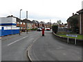
2
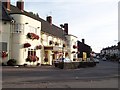
The Three Horseshoes
Public house on Witton Lane.
Image: © Richard Law
Taken: 27 Jul 2012
0.15 miles
3
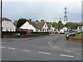
Bungalows on Conway Avenue
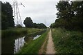
The distant pylon marks the line of the Tame Valley canal.
Image: © Peter Whatley
Taken: 11 May 2010
0.22 miles
4
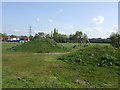
Balls Hill Play Area
No play area is complete without a mound or two.
Image: © John M
Taken: 16 Apr 2011
0.22 miles

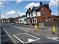
7
The Gough Arms, Hateley Heath
The curvy architecture give this away as constructed between the wars.
Image: © Adrian Bailey
Taken: 21 Aug 2005
0.25 miles
8
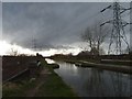
Storm Clouds Over Tame Valley
Tame Valley Canal at Hydes road bridge.
Image: © Gordon Griffiths
Taken: 18 Mar 2007
0.25 miles