IMAGES TAKEN NEAR TO
Crookhay Lane, WEST BROMWICH, B71 2NF
Introduction
This page details the photographs taken nearby to Crookhay Lane, B71 2NF by members of the Geograph project.
The Geograph project started in 2005 with the aim of publishing, organising and preserving representative images for every square kilometre of Great Britain, Ireland and the Isle of Man.

There are currently over 7.5m images from over14,400 individuals and you can help contribute to the project by visiting https://www.geograph.org.uk
Image Map
Images are licensed for reuse under creativecommons.org/licenses/by-sa/2.0
Notes
- Clicking on the map will re-center to the selected point.
- The higher the marker number, the further away the image location is from the centre of the postcode.
Image Listing (16 Images Found)
Images are licensed for reuse under creativecommons.org/licenses/by-sa/2.0
Image
Details
Distance
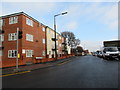
1
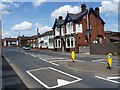
The Three Horseshoes
Public house on Witton Lane.
Image: © Richard Law
Taken: 27 Jul 2012
0.08 miles
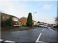
4
Bethesda Christian Fellowship church
A small, modern church on Witton Lane, south of Wednesbury.
Image: © Richard Law
Taken: 27 Jul 2012
0.11 miles
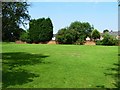
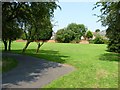
5
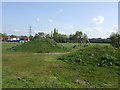
Balls Hill Play Area
No play area is complete without a mound or two.
Image: © John M
Taken: 16 Apr 2011
0.13 miles
9
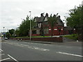
Hill Top, old police station
On Hill Top; former police station to left, sergeant's house to right. Dated 1897, now serving as community centre & library.
Image: © Mike Faherty
Taken: 8 Jun 2009
0.20 miles
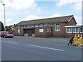
10
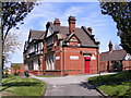
Hill Top Centre
The Community Centre and Library at Hill Top,West Bromwich.
Image: © Gordon Griffiths
Taken: 21 Apr 2009
0.20 miles