IMAGES TAKEN NEAR TO
Alexandra Way, OLDBURY, B69 2LX
Introduction
This page details the photographs taken nearby to Alexandra Way, B69 2LX by members of the Geograph project.
The Geograph project started in 2005 with the aim of publishing, organising and preserving representative images for every square kilometre of Great Britain, Ireland and the Isle of Man.

There are currently over 7.5m images from over14,400 individuals and you can help contribute to the project by visiting https://www.geograph.org.uk
Image Map
Images are licensed for reuse under creativecommons.org/licenses/by-sa/2.0
Notes
- Clicking on the map will re-center to the selected point.
- The higher the marker number, the further away the image location is from the centre of the postcode.
Image Listing (48 Images Found)
Images are licensed for reuse under creativecommons.org/licenses/by-sa/2.0
Image
Details
Distance
1
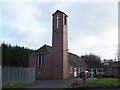
St Michael The Archangel, Tividale
Situated in Tividale Road, the church was opened in 1995, using, as a basis, the hall of the original church, which stood from 1878 to 1984
Image: © Geoff Pick
Taken: 5 Dec 2009
0.07 miles
2
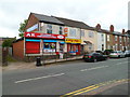
Convenience store and Village Chippy, Tividale
Viewed across Tividale Road from the corner of Gate Street.
The two shops are AK off-licence & convenience store, and Village Chippy, selling fish & chips, kebabs, pizzas, burgers, pies, southern-fried chicken, etc.
Image: © Jaggery
Taken: 5 May 2012
0.09 miles
3
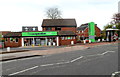
Co-operative Food store, Tividale
The store opened in August 2010. This location, on the corner of Dudley Road West and Groveland Road, was previously the site of The Waggon and Horses pub.
Image: © Jaggery
Taken: 5 May 2012
0.10 miles
4
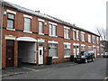
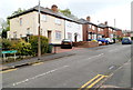
Walford Street
Victorian terraced houses with archway to rear.
Image: © Burgess Von Thunen
Taken: 21 Feb 2013
0.12 miles
5
Princes Road, Tividale
Houses on the east side of the road, viewed from the Dudley Road West end.
Image: © Jaggery
Taken: 5 May 2012
0.13 miles
6
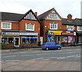
Two Tividale Road shops, Tividale
On the left is Violet Miller Florist. On the right is K2 Express Supermarket.
Image: © Jaggery
Taken: 5 May 2012
0.15 miles
7
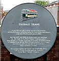
Tividale Trams plaque
Located on a wall at the Tividale Road end of Hopkins Street.
The plaque records a potted history of trams in the area. From 1885 to 1939, Tividale was served by tramcars on the Birmingham to Dudley route. The trams were steam-hauled until electrification in 1903. The tramcar illustrated is Dudley and Stourbridge No 5, built at Tividale in 1920 and now preserved at the Black Country Museum.
Image: © Jaggery
Taken: 5 May 2012
0.15 miles
8
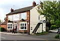
The Wonder, Tividale
Pub on the north side of Dudley Road West.
Image: © Jaggery
Taken: 5 May 2012
0.16 miles
9
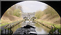
Netherton Tunnel and Tividale Aqueduct
Coming out of the northern end of Netherton Tunnel, Dudley, looking towards Tividale Aqueduct, which carries the Wolverhampton Canal Level over the Netherton Tunnel Branch.
Image: © Martin Clark
Taken: Unknown
0.18 miles
10
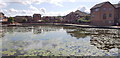
Tividale Quays Basin, Tipton
A peaceful scene. No boats were in evidence, just a few anglers. A far cry from times past, when this area was full of heavy industry.
Image: © Paul Collins
Taken: 18 Aug 2019
0.18 miles