IMAGES TAKEN NEAR TO
Pine Road, OLDBURY, B69 1UA
Introduction
This page details the photographs taken nearby to Pine Road, B69 1UA by members of the Geograph project.
The Geograph project started in 2005 with the aim of publishing, organising and preserving representative images for every square kilometre of Great Britain, Ireland and the Isle of Man.

There are currently over 7.5m images from over14,400 individuals and you can help contribute to the project by visiting https://www.geograph.org.uk
Image Map
Images are licensed for reuse under creativecommons.org/licenses/by-sa/2.0
Notes
- Clicking on the map will re-center to the selected point.
- The higher the marker number, the further away the image location is from the centre of the postcode.
Image Listing (13 Images Found)
Images are licensed for reuse under creativecommons.org/licenses/by-sa/2.0
Image
Details
Distance
1
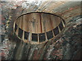
Netherton Tunnel air shaft.
An air shaft in the Netherton canal tunnel. Taken with a flash as the tunnel is unlit and in complete darkness for its full 2768 metre length. I believe this the shaft that opens out in an island in the middle of Aston Road, Tividale Hall. http://en.wikipedia.org/wiki/Netherton_Tunnel
Image: © Peter Evans
Taken: 20 Apr 2013
0.12 miles
2
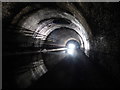
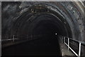
Inside the Netherton Tunnel
The tunnel is lit up by the light of an oncoming narrowboat, about to pass under airshaft 12.
The Netherton Tunnel was constructed between 1855–1858 and was opened on 20 August 1858 at a cost of £302,000, providing a waterway connection between the Black Country towns of Netherton and Tipton.
It lies on the Netherton Tunnel Branch Canal and has a length of 9,081 feet (2,768 m).
It was built to relieve the bottleneck of the adjacent Dudley Tunnel. The tunnel has a width of 27 feet (8.2 m) allowing two way narrowboat traffic, it has a towpath on each side.
Image: © Mat Fascione
Taken: 16 Apr 2017
0.12 miles
3
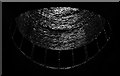
Air Shaft No.14 of the Netherton Tunnel
This airshaft is about 700 metres from the northern portal of the tunnel. The top of the airshaft is on Packwood Road in Tividale.
The Netherton Tunnel was constructed between 1855–1858 and was opened on 20 August 1858 at a cost of £302,000, providing a waterway connection between the Black Country towns of Netherton and Tipton.
It lies on the Netherton Tunnel Branch Canal and has a length of 9,081 feet (2,768 m).
It was built to relieve the bottleneck of the adjacent Dudley Tunnel. The tunnel has a width of 27 feet (8.2 m) allowing two way narrowboat traffic, it has a towpath on each side.
Image: © Mat Fascione
Taken: 16 Apr 2017
0.13 miles
4
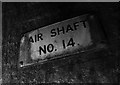
Sign at air shaft No.14 of the Netherton Tunnel
This airshaft is about 700 metres from the northern portal of the tunnel. The top of the airshaft is on Packwood Road in Tividale.
The Netherton Tunnel was constructed between 1855–1858 and was opened on 20 August 1858 at a cost of £302,000, providing a waterway connection between the Black Country towns of Netherton and Tipton.
It lies on the Netherton Tunnel Branch Canal and has a length of 9,081 feet (2,768 m).
It was built to relieve the bottleneck of the adjacent Dudley Tunnel. The tunnel has a width of 27 feet (8.2 m) allowing two way narrowboat traffic, it has a towpath on each side.
Image: © Mat Fascione
Taken: 16 Apr 2017
0.13 miles
5
Netherton Tunnel
The last tunnel built at a cost of over £300,000 it opened on the 20th of August 1858. It was built with two tow paths and wide enough for two boats. Thus is eased congestion in the narrow Dudley tunnel that had to be legged through. Its over 2.5km long, straight and now unlit. Take a torch!
One of the air shafts, this one is wet but others are dry.
Image: © Ashley Dace
Taken: 24 Mar 2011
0.18 miles
6
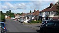
Regent Drive
Regent Drive is a cul-de-sac and the picture captures the semi-detached housing typical of this area.
Image: © Peter Mackenzie
Taken: 20 Aug 2017
0.20 miles
7
The Red Mango
An Indian restaurant in Oldbury
Image: © Stephen Rogerson
Taken: 24 Apr 2014
0.23 miles
8

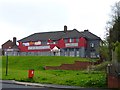
Tividale Hall Primary School
Primary school on Regent Road, Oldbury, which is part of the Sandwell (Dudley) Local Authority education department.
Image: © Richard Law
Taken: 20 Jul 2012
0.23 miles
9
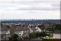
Darby's Hill View
Birmingham city centre as viewed from Darby's Hill.
Image: © Alan Atkins
Taken: 29 Aug 2005
0.23 miles
10

Netherton Tunnel
The last tunnel built at a cost of over £300,000 it opened on the 20th of August 1858. It was built with two tow paths and wide enough for two boats. Thus it eased congestion in the narrow Dudley tunnel that had to be legged through. It's over 2.5km long, straight and now unlit. Take a torch!
This is a 20 second exposure without a tripod, I plan to go again with one as some fantastic photographs are possible.
Image: © Ashley Dace
Taken: 24 Mar 2011
0.24 miles