IMAGES TAKEN NEAR TO
Oakham Road, OLDBURY, B69 1PT
Introduction
This page details the photographs taken nearby to Oakham Road, B69 1PT by members of the Geograph project.
The Geograph project started in 2005 with the aim of publishing, organising and preserving representative images for every square kilometre of Great Britain, Ireland and the Isle of Man.

There are currently over 7.5m images from over14,400 individuals and you can help contribute to the project by visiting https://www.geograph.org.uk
Image Map
Images are licensed for reuse under creativecommons.org/licenses/by-sa/2.0
Notes
- Clicking on the map will re-center to the selected point.
- The higher the marker number, the further away the image location is from the centre of the postcode.
Image Listing (24 Images Found)
Images are licensed for reuse under creativecommons.org/licenses/by-sa/2.0
Image
Details
Distance
1
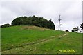
Darby's Hill
A view of the mobile phone mast and trees on top of Darby's Hill.
Image: © Alan Atkins
Taken: 29 Aug 2005
0.11 miles
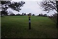
2
Mast from View Point
This road on Darby's Hill is called View Point.
Image: © Gordon Griffiths
Taken: 8 Apr 2007
0.13 miles
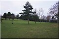
3
View Point
The view from Darby's Hill towards Turner's Hill masts.
Image: © Gordon Griffiths
Taken: 11 Dec 2010
0.15 miles
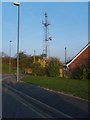
4
Darbys Hill Road
The view up to the mast on Darby's Hill, Dudley.
Image: © Gordon Griffiths
Taken: 11 Dec 2010
0.16 miles
5
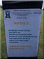
Public footpath safety notice at Dudley Golf Course
Image: © Ian S
Taken: 17 Dec 2021
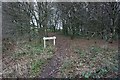
0.18 miles
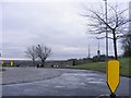
9
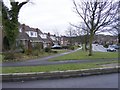
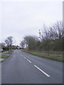
Darbys Hill Road View
The view down Oakham Road, Dudley.
Image: © Gordon Griffiths
Taken: 11 Dec 2010
0.18 miles