IMAGES TAKEN NEAR TO
Tudor Road, OLDBURY, B68 9RA
Introduction
This page details the photographs taken nearby to Tudor Road, B68 9RA by members of the Geograph project.
The Geograph project started in 2005 with the aim of publishing, organising and preserving representative images for every square kilometre of Great Britain, Ireland and the Isle of Man.

There are currently over 7.5m images from over14,400 individuals and you can help contribute to the project by visiting https://www.geograph.org.uk
Image Map
Images are licensed for reuse under creativecommons.org/licenses/by-sa/2.0
Notes
- Clicking on the map will re-center to the selected point.
- The higher the marker number, the further away the image location is from the centre of the postcode.
Image Listing (12 Images Found)
Images are licensed for reuse under creativecommons.org/licenses/by-sa/2.0
Image
Details
Distance
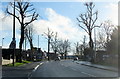
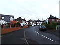
1
View up Matty Road from Brookfields Road
Image: © Richard Law
Taken: 20 May 2019
0.04 miles
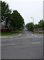
6
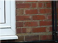
OS benchmark - Londonderry, 9 Reservoir Road
An OS cutmark beside the front door of 9 Reservoir Road; originally levelled in 1956 at 195.151, above Ordnance Datum Newlyn.
Image: © Richard Law
Taken: 20 May 2019
0.18 miles
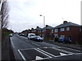
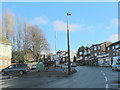
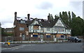
7
The Merrivale, Langley
A pub on the eastern edge of Langley.
Image: © David Weston
Taken: 11 Oct 2015
0.19 miles
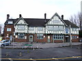
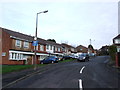
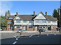
9
The Merrivale, Oldbury
Damaged by fire in 2019.
Image: © JThomas
Taken: 22 Aug 2019
0.20 miles