IMAGES TAKEN NEAR TO
Wilson Road, OLDBURY, B68 9JW
Introduction
This page details the photographs taken nearby to Wilson Road, B68 9JW by members of the Geograph project.
The Geograph project started in 2005 with the aim of publishing, organising and preserving representative images for every square kilometre of Great Britain, Ireland and the Isle of Man.

There are currently over 7.5m images from over14,400 individuals and you can help contribute to the project by visiting https://www.geograph.org.uk
Image Map
Images are licensed for reuse under creativecommons.org/licenses/by-sa/2.0
Notes
- Clicking on the map will re-center to the selected point.
- The higher the marker number, the further away the image location is from the centre of the postcode.
Image Listing (9 Images Found)
Images are licensed for reuse under creativecommons.org/licenses/by-sa/2.0
Image
Details
Distance
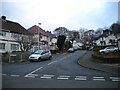
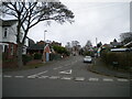
2
Harborne Road, Warley
Along the western edge of Warley Park.
Image: © Richard Vince
Taken: 3 Dec 2022
0.06 miles
3
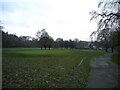
North end of Warley Woods golf course
Seen from the footpath leading from Harborne Road into Warley Park.
Image: © Richard Vince
Taken: 3 Dec 2022
0.11 miles
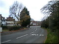
4
Warley Hall Road, Warley
Off Wilson Road.
Image: © Richard Vince
Taken: 3 Dec 2022
0.12 miles
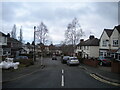
5
Lenwade Road, Warley
Leading from Hadzor Road to Harborne Road.
Image: © Richard Vince
Taken: 3 Dec 2022
0.16 miles

7
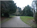
Footpath in Warley Park (2)
Leading eventually to Harborne Road, which forms the western perimeter of the park.
Image: © Richard Vince
Taken: 3 Dec 2022
0.22 miles

9
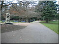
Footpath in Warley Park (1)
Leading to Abbey Road, which forms the northern perimeter of the park.
Image: © Richard Vince
Taken: 3 Dec 2022
0.24 miles