IMAGES TAKEN NEAR TO
Abbey Crescent, OLDBURY, B68 9HH
Introduction
This page details the photographs taken nearby to Abbey Crescent, B68 9HH by members of the Geograph project.
The Geograph project started in 2005 with the aim of publishing, organising and preserving representative images for every square kilometre of Great Britain, Ireland and the Isle of Man.

There are currently over 7.5m images from over14,400 individuals and you can help contribute to the project by visiting https://www.geograph.org.uk
Image Map
Images are licensed for reuse under creativecommons.org/licenses/by-sa/2.0
Notes
- Clicking on the map will re-center to the selected point.
- The higher the marker number, the further away the image location is from the centre of the postcode.
Image Listing (11 Images Found)
Images are licensed for reuse under creativecommons.org/licenses/by-sa/2.0
Image
Details
Distance
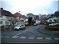

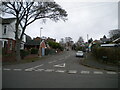
3
Warley Hall Road, Warley
Off Wilson Road.
Image: © Richard Vince
Taken: 3 Dec 2022
0.15 miles
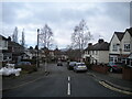
4
Harborne Road, Warley
Along the western edge of Warley Park.
Image: © Richard Vince
Taken: 3 Dec 2022
0.15 miles
5
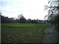
North end of Warley Woods golf course
Seen from the footpath leading from Harborne Road into Warley Park.
Image: © Richard Vince
Taken: 3 Dec 2022
0.20 miles
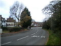
6
Lenwade Road, Warley
Leading from Hadzor Road to Harborne Road.
Image: © Richard Vince
Taken: 3 Dec 2022
0.21 miles
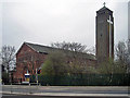
7

Our Lady and St Hubert
http://www.sthubertswarley.org.uk/
Image: © Stephen Rogerson
Taken: 5 Jun 2014
0.22 miles
9
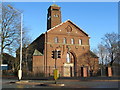
Bleakhouse Road and Our Lady & Saint Hubert Church
Image: © Roy Hughes
Taken: 1 Jan 2018
0.24 miles
10
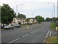
Wolverhampton Road
A rare view, even for a Sunday these days, with very little traffic in evidence.
Image: © David Stowell
Taken: 2 Jul 2006
0.24 miles