IMAGES TAKEN NEAR TO
Rood End Road, OLDBURY, B68 8SR
Introduction
This page details the photographs taken nearby to Rood End Road, B68 8SR by members of the Geograph project.
The Geograph project started in 2005 with the aim of publishing, organising and preserving representative images for every square kilometre of Great Britain, Ireland and the Isle of Man.

There are currently over 7.5m images from over14,400 individuals and you can help contribute to the project by visiting https://www.geograph.org.uk
Image Map
Images are licensed for reuse under creativecommons.org/licenses/by-sa/2.0
Notes
- Clicking on the map will re-center to the selected point.
- The higher the marker number, the further away the image location is from the centre of the postcode.
Image Listing (11 Images Found)
Images are licensed for reuse under creativecommons.org/licenses/by-sa/2.0
Image
Details
Distance
5
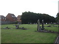
Oldbury Cemetery
St Pauls Road, West Smethwick.
Image: © JThomas
Taken: 22 Aug 2019
0.12 miles
6
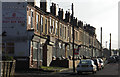
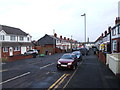
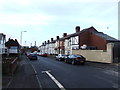
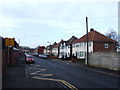
Rood End, Oldbury
Photograph looking south along Barker Street showing typical Black Country Victorian housing.
Image: © David Ellis
Taken: 27 Oct 2005
0.13 miles
7

The boating lake in West Smethwick Park
I'm not convinced there's much interest in rowing boats around this lake these days; pastimes have changed since the genteel Victorian era.
Image: © Richard Law
Taken: 20 May 2019
0.17 miles
9
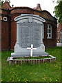
Rood End War Memorial
Grade II listed https://britishlistedbuildings.co.uk/101434723-rood-end-war-memorial-st-pauls-ward#.XQHwW4hKhPY & https://historicengland.org.uk/listing/the-list/list-entry/1434723 in 2016, the memorial commemorates those men of the town who died in WWI. It was erected in 1921, and without alteration after the 2nd war, it is described as "thus retains its original design intent."
Image: © Richard Law
Taken: 20 May 2019
0.21 miles