IMAGES TAKEN NEAR TO
Thompson Road, OLDBURY, B68 8QD
Introduction
This page details the photographs taken nearby to Thompson Road, B68 8QD by members of the Geograph project.
The Geograph project started in 2005 with the aim of publishing, organising and preserving representative images for every square kilometre of Great Britain, Ireland and the Isle of Man.

There are currently over 7.5m images from over14,400 individuals and you can help contribute to the project by visiting https://www.geograph.org.uk
Image Map
Images are licensed for reuse under creativecommons.org/licenses/by-sa/2.0
Notes
- Clicking on the map will re-center to the selected point.
- The higher the marker number, the further away the image location is from the centre of the postcode.
Image Listing (54 Images Found)
Images are licensed for reuse under creativecommons.org/licenses/by-sa/2.0
Image
Details
Distance
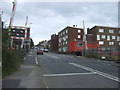
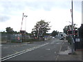
1
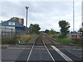
Railway towards Rowley Regis
From the level crossing on the B4182, Oldbury.
Image: © JThomas
Taken: 22 Aug 2019
0.03 miles
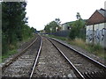
3
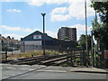
Level crossing at Langley
Seen from the Station Road side of the crossing; the other side is Crosswells Road. Thompson Road is seen on the left of the photo. In the distance is Alfred Gunn House.
Image: © David Weston
Taken: 15 Jul 2018
0.05 miles
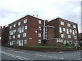
6
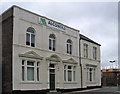
Langley Green - offices on Crosswells Road
Image: © Dave Bevis
Taken: 19 Apr 2014
0.06 miles
7
Railway towards Langley Green Station
From the level crossing on the B4182, Oldbury.
Image: © JThomas
Taken: 22 Aug 2019
0.08 miles
8
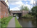
Titford Canal - New Inns Road Bridge
The original arched iron bridge in the centre has been widened on both sides. The pub is the Bridge Inn.
Image: © John M
Taken: 25 Apr 2009
0.10 miles
9
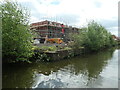
Building site alongside the Titford Canal
New housing on Waterside Crescent is replacing industrial buildings.
Image: © Christine Johnstone
Taken: 10 May 2022
0.10 miles
10
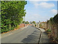
Mill Lane, Langley
Everything on Mill Lane has been demolished. There used to be a factory, Langley Forge, on the left, and terrace houses on the right. I used to wonder how the people in the houses coped with the noise from the forge.
Image: © David Weston
Taken: 11 Oct 2015
0.10 miles