IMAGES TAKEN NEAR TO
Wolverhampton Road, OLDBURY, B68 8DD
Introduction
This page details the photographs taken nearby to Wolverhampton Road, B68 8DD by members of the Geograph project.
The Geograph project started in 2005 with the aim of publishing, organising and preserving representative images for every square kilometre of Great Britain, Ireland and the Isle of Man.

There are currently over 7.5m images from over14,400 individuals and you can help contribute to the project by visiting https://www.geograph.org.uk
Image Map
Images are licensed for reuse under creativecommons.org/licenses/by-sa/2.0
Notes
- Clicking on the map will re-center to the selected point.
- The higher the marker number, the further away the image location is from the centre of the postcode.
Image Listing (8 Images Found)
Images are licensed for reuse under creativecommons.org/licenses/by-sa/2.0
Image
Details
Distance
2
Brandhall Covert
The view off Heron Road of the brook contained between the houses.
Image: © Gordon Griffiths
Taken: 3 Sep 2010
0.11 miles
3
Brandhall Golf Club
The view off Heron Road, Blackheath.
Image: © Gordon Griffiths
Taken: 3 Sep 2010
0.12 miles
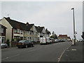
4
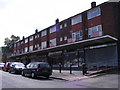
Brook Road Shops
The shop and flats in the Blackheath Road.
Image: © Gordon Griffiths
Taken: 3 Sep 2010
0.15 miles
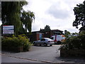
6
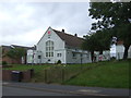
The Salvation Army Church and Community Centre
On Pound Road.
Image: © JThomas
Taken: 22 Aug 2019
0.23 miles
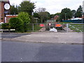
7
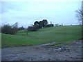
Bristnall Fields Golf Course
Currently undergoing some major repairs
Image: © Tim Lloydlangston
Taken: 20 Feb 2007
0.24 miles
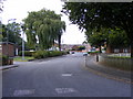
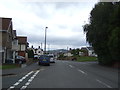
8
Pound Road, Oldbury
The top of a hill: the road meets the A4123 (Wolverhampton Road) at the bottom.
Image: © David Weston
Taken: 11 Oct 2015
0.24 miles