IMAGES TAKEN NEAR TO
Brennand Road, OLDBURY, B68 0SE
Introduction
This page details the photographs taken nearby to Brennand Road, B68 0SE by members of the Geograph project.
The Geograph project started in 2005 with the aim of publishing, organising and preserving representative images for every square kilometre of Great Britain, Ireland and the Isle of Man.

There are currently over 7.5m images from over14,400 individuals and you can help contribute to the project by visiting https://www.geograph.org.uk
Image Map
Images are licensed for reuse under creativecommons.org/licenses/by-sa/2.0
Notes
- Clicking on the map will re-center to the selected point.
- The higher the marker number, the further away the image location is from the centre of the postcode.
Image Listing (7 Images Found)
Images are licensed for reuse under creativecommons.org/licenses/by-sa/2.0
Image
Details
Distance
2
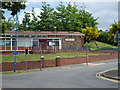
Brandhall Library
The Library stands on Tame Road.
Image: © Gordon Griffiths
Taken: 24 May 2007
0.19 miles
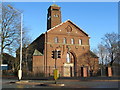
3
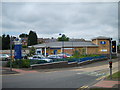
King's Community Church, Brandhall
Last photographed in 2007, and virtually unchanged since then Image
Image: © Richard Law
Taken: 2 Oct 2019
0.21 miles
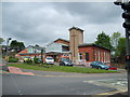
4
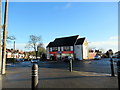
Brandhall Co op
The Supermarket stands on Tame Road.
Image: © Gordon Griffiths
Taken: 24 May 2007
0.22 miles
5
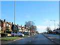
Wolverhampton Road Near Our Lady & Saint Hubert Church
Image: © Roy Hughes
Taken: 1 Jan 2018
0.24 miles
6
Bleakhouse Road and Our Lady & Saint Hubert Church
Image: © Roy Hughes
Taken: 1 Jan 2018
0.24 miles
7
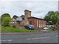
King's Community Church
The Church stands on Tame Road ,Brandhall.
Image: © Gordon Griffiths
Taken: 24 May 2007
0.24 miles