IMAGES TAKEN NEAR TO
Holly Road, OLDBURY, B68 0AU
Introduction
This page details the photographs taken nearby to Holly Road, B68 0AU by members of the Geograph project.
The Geograph project started in 2005 with the aim of publishing, organising and preserving representative images for every square kilometre of Great Britain, Ireland and the Isle of Man.

There are currently over 7.5m images from over14,400 individuals and you can help contribute to the project by visiting https://www.geograph.org.uk
Image Map
Images are licensed for reuse under creativecommons.org/licenses/by-sa/2.0
Notes
- Clicking on the map will re-center to the selected point.
- The higher the marker number, the further away the image location is from the centre of the postcode.
Image Listing (3 Images Found)
Images are licensed for reuse under creativecommons.org/licenses/by-sa/2.0
Image
Details
Distance
2
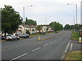
Wolverhampton Road
A rare view, even for a Sunday these days, with very little traffic in evidence.
Image: © David Stowell
Taken: 2 Jul 2006
0.19 miles
3
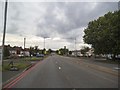
A4123 View
The view down the Wolverhampton Road towards the white cross on Our Lady and St Hubert Catholic Church in Warley, Sandwell.
Image: © Gordon Griffiths
Taken: 13 Sep 2015
0.20 miles