IMAGES TAKEN NEAR TO
Tame Road, BIRMINGHAM, B6 7HL
Introduction
This page details the photographs taken nearby to Tame Road, B6 7HL by members of the Geograph project.
The Geograph project started in 2005 with the aim of publishing, organising and preserving representative images for every square kilometre of Great Britain, Ireland and the Isle of Man.

There are currently over 7.5m images from over14,400 individuals and you can help contribute to the project by visiting https://www.geograph.org.uk
Image Map (Loading...)


Getting Data...Please wait
Leaflet Map data © OpenStreetMap
Images are licensed for reuse under creativecommons.org/licenses/by-sa/2.0
Notes
- Clicking on the map will re-center to the selected point.
- The higher the marker number, the further away the image location is from the centre of the postcode.
Image Listing (68 Images Found)
Images are licensed for reuse under creativecommons.org/licenses/by-sa/2.0
Image
Details
Distance
1
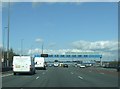
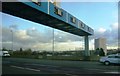
Overhead Gantry
Overhead gantry Aston Express Way Aston, Birmingham.
Image: © Keith Evans
Taken: 26 Mar 2009
0.09 miles
2
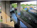
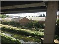
River Tame Passing Underneath Aston Expressway A38(M)
Image: © Roy Hughes
Taken: 25 May 2013
0.11 miles
3
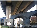
River Tame
The River Tame and railway provided a challenge to the engineers designing the Aston Expressway from Birmingham City Centre to the M6 at Spaghetti Junction.
Image: © John M
Taken: 6 Feb 2008
0.12 miles
4

Benchmark on #187 Tame Road
Ordnance Survey cut mark benchmark described on the Bench Mark Database at http://www.bench-marks.org.uk/bm46131
Image: © Roger Templeman
Taken: 10 Nov 2012
0.13 miles
5
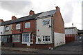
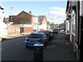
Houses on Tame Road
There is an OS benchmark Image on the white-painted bricks on the side face of the right hand house in the row
Image: © Roger Templeman
Taken: 10 Nov 2012
0.13 miles
6
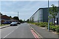
Waterworks Street, Aston
In line with Waterworks Street and Aston Hall Road beyond is the spire of St Peter and St Paul, Aston. On the right, more of the 'new industrial & warehouse units' seen in Image In the past a waterworks produced drinking water from the River Tame. The reservoir is the main feature of Salford Park.
Image reference: 7511983
Image: © Robin Stott
Taken: 29 May 2023
0.15 miles
9
River Tame below the Aston Expressway, Aston, Birmingham
The river, flowing away from the camera, has taken a sharp turn northeast. Photographed from a Lichfield-New Street London Midland train.
Image: © Robin Stott
Taken: 25 Jul 2016
0.15 miles
10

The Aston Tavern
This now closed pub is on Aston Hall Road and is in the shadow of The Aston Expressway on the right hand side.
Image: © Carl Baker
Taken: 2 Nov 2006
0.15 miles