IMAGES TAKEN NEAR TO
Westwood Road, BIRMINGHAM, B6 7DX
Introduction
This page details the photographs taken nearby to Westwood Road, B6 7DX by members of the Geograph project.
The Geograph project started in 2005 with the aim of publishing, organising and preserving representative images for every square kilometre of Great Britain, Ireland and the Isle of Man.

There are currently over 7.5m images from over14,400 individuals and you can help contribute to the project by visiting https://www.geograph.org.uk
Image Map
Images are licensed for reuse under creativecommons.org/licenses/by-sa/2.0
Notes
- Clicking on the map will re-center to the selected point.
- The higher the marker number, the further away the image location is from the centre of the postcode.
Image Listing (20 Images Found)
Images are licensed for reuse under creativecommons.org/licenses/by-sa/2.0
Image
Details
Distance
1
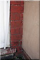
Half a benchmark on #91 Electric Avenue
Ordnance Survey cut mark benchmark described on the Bench Mark Database at http://www.bench-marks.org.uk/bm46118
Image: © Roger Templeman
Taken: 10 Nov 2012
0.10 miles
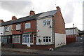
2

Houses and a sandwich bar on Electric Avenue
There is an OS benchmark Image at the junction of the two houses
Image: © Roger Templeman
Taken: 10 Nov 2012
0.10 miles
3
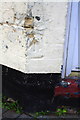
Benchmark on #74 Tame Road
Ordnance Survey cut mark benchmark described on the Bench Mark Database at http://www.bench-marks.org.uk/bm46133
Image: © Roger Templeman
Taken: 10 Nov 2012
0.11 miles
4
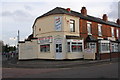
Jenny's Diner, #74 Tame Road
There is an OS benchmark Image on the bricks to the left of the door
Image: © Roger Templeman
Taken: 10 Nov 2012
0.12 miles
5
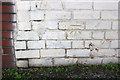
Benchmark on #187 Tame Road
Ordnance Survey cut mark benchmark described on the Bench Mark Database at http://www.bench-marks.org.uk/bm46131
Image: © Roger Templeman
Taken: 10 Nov 2012
0.13 miles
6
Houses on Tame Road
There is an OS benchmark Image on the white-painted bricks on the side face of the right hand house in the row
Image: © Roger Templeman
Taken: 10 Nov 2012
0.13 miles
7
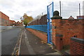
Wall of Deykin Avenue School, Wyrley Road
There is an OS benchmark Image on the end of wall pier next to the blue gate.
Image: © Roger Templeman
Taken: 10 Nov 2012
0.18 miles
8

Benchmark on wall pier of Deykin Avenue School, Wyrley Road
Ordnance Survey cut mark benchmark described on the Bench Mark Database at http://www.bench-marks.org.uk/bm46124
Image: © Roger Templeman
Taken: 10 Nov 2012
0.19 miles
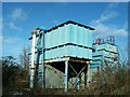
10

Fine Hq Building
now a facade for a plumbing warehouse
Image: © David Bagshaw
Taken: 3 Jan 2006
0.20 miles