IMAGES TAKEN NEAR TO
Tame Road, BIRMINGHAM, B6 7DT
Introduction
This page details the photographs taken nearby to Tame Road, B6 7DT by members of the Geograph project.
The Geograph project started in 2005 with the aim of publishing, organising and preserving representative images for every square kilometre of Great Britain, Ireland and the Isle of Man.

There are currently over 7.5m images from over14,400 individuals and you can help contribute to the project by visiting https://www.geograph.org.uk
Image Map (Loading...)


Getting Data...Please wait
Leaflet Map data © OpenStreetMap
Images are licensed for reuse under creativecommons.org/licenses/by-sa/2.0
Notes
- Clicking on the map will re-center to the selected point.
- The higher the marker number, the further away the image location is from the centre of the postcode.
Image Listing (36 Images Found)
Images are licensed for reuse under creativecommons.org/licenses/by-sa/2.0
Image
Details
Distance
1
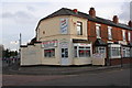
Jenny's Diner, #74 Tame Road
There is an OS benchmark Image on the bricks to the left of the door
Image: © Roger Templeman
Taken: 10 Nov 2012
0.04 miles
2
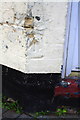
Benchmark on #74 Tame Road
Ordnance Survey cut mark benchmark described on the Bench Mark Database at http://www.bench-marks.org.uk/bm46133
Image: © Roger Templeman
Taken: 10 Nov 2012
0.05 miles
3
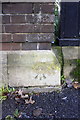
Benchmark on Brookvale Road bridge
Ordnance Survey cut mark benchmark described on the Bench Mark Database at http://www.bench-marks.org.uk/bm40039
Image: © Roger Templeman
Taken: 10 Nov 2012
0.09 miles
4
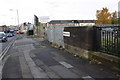
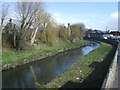
Parapet of Brookvale Road bridge over River Tame
There is an OS benchmark Image on the stone base of the parapet at the junction of its brick section with the section with railings on top. On the right past the bridge is the entrance to a car park for Aston Villa staff.
Image: © Roger Templeman
Taken: 10 Nov 2012
0.09 miles
7
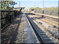
Witton railway station, Birmingham
Opened in 1876 by the London & North Western Railway on the line from Birmingham via Bescot to Stafford. View north west towards Perry Barr and Bescot.
Image: © Nigel Thompson
Taken: 22 Oct 2011
0.14 miles
8
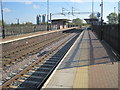
Witton railway station, Birmingham
Opened in 1876 by the London & North Western Railway on the line from Birmingham via Bescot to Stafford. View south east towards Aston and Birmingham.
Image: © Nigel Thompson
Taken: 22 Oct 2011
0.15 miles
9
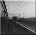
Witton Station
View from train heading for Birmingham New Street, showing buildings on opposite platform. Despite poor quality, the church on skyline on right is Aston Parish Church alongside Aston Expressway on Witton Lane Image]
Image: © Michael Westley
Taken: Unknown
0.16 miles
10
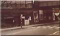
Witton Station, Birmingham
Entrance to northern platform, for trains to Birmingham, showing an old-fashioned zebra crossing light. The bridge on the right takes the outer ring-road A4040 under the railway, towards Perry Barr.
On matchdays the station will sometimes see the arrival and departure of football supporters, as the station is very close to Aston Villa ground.
Image: © Michael Westley
Taken: Unknown
0.16 miles