IMAGES TAKEN NEAR TO
Chancel Way Industrial Estate, Chancel Way, BIRMINGHAM, B6 7AU
Introduction
This page details the photographs taken nearby to Chancel Way Industrial Estate, Chancel Way, B6 7AU by members of the Geograph project.
The Geograph project started in 2005 with the aim of publishing, organising and preserving representative images for every square kilometre of Great Britain, Ireland and the Isle of Man.

There are currently over 7.5m images from over14,400 individuals and you can help contribute to the project by visiting https://www.geograph.org.uk
Image Map (38 Images)


Getting Data...Please wait
Leaflet Map data © OpenStreetMap
Images are licensed for reuse under creativecommons.org/licenses/by-sa/2.0
Notes
- Clicking on the map will re-center to the selected point.
- The higher the marker number, the further away the image location is from the centre of the postcode.
Image Listing (38 Images Found)
Images are licensed for reuse under creativecommons.org/licenses/by-sa/2.0
Image
Details
Distance
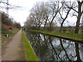
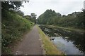
2
Tame Valley Canal towards Perry Barr Lock #11
Image: © Ian S
Taken: 25 Jul 2021
0.07 miles
4
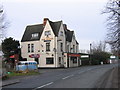
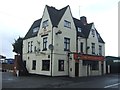
The Safe Harbour Pub, Moor Lane, Witton.
On Moor Lane opposite one of the entrances to Birmingham City Cemetery. This pub was once know by the very appropriate name "The Grave Diggers"
Image: © Roy Hughes
Taken: 24 Jan 2009
0.09 miles
5
Tame Valley Canal towards Perry Barr Lock #11
Image: © Ian S
Taken: 25 Jul 2021
0.10 miles
6
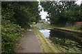
Tame Valley Canal towards Perry Barr Lock #11
Image: © Ian S
Taken: 25 Jul 2021
0.10 miles


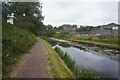
9
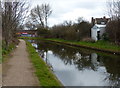
Tame Valley Canal at Witton, Birmingham
Image: © Mat Fascione
Taken: 1 Apr 2018
0.12 miles