IMAGES TAKEN NEAR TO
Buttery Road, SMETHWICK, B67 7NS
Introduction
This page details the photographs taken nearby to Buttery Road, B67 7NS by members of the Geograph project.
The Geograph project started in 2005 with the aim of publishing, organising and preserving representative images for every square kilometre of Great Britain, Ireland and the Isle of Man.

There are currently over 7.5m images from over14,400 individuals and you can help contribute to the project by visiting https://www.geograph.org.uk
Image Map
Images are licensed for reuse under creativecommons.org/licenses/by-sa/2.0
Notes
- Clicking on the map will re-center to the selected point.
- The higher the marker number, the further away the image location is from the centre of the postcode.
Image Listing (7 Images Found)
Images are licensed for reuse under creativecommons.org/licenses/by-sa/2.0
Image
Details
Distance
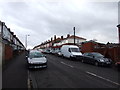
1
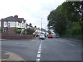
Holly Lane, Smethwick
Junction with Devonshire Drive.
Image: © JThomas
Taken: 22 Aug 2019
0.09 miles
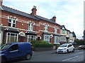
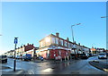
3
St Paul's Road Post Office, 30 St Paul's Road
On the corner of St Paul's Road and Bertram Road, this is a post office, convenience store and off-licence.
Image: © P L Chadwick
Taken: 16 Aug 2010
0.24 miles
4
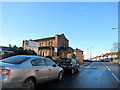
St Paul's Road West Smethwick Methodist Church
Image: © Roy Hughes
Taken: 1 Jan 2018
0.24 miles
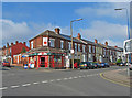
6
St Pauls Road Bertram Road Junction Sandwell
Image: © Roy Hughes
Taken: 1 Jan 2018
0.24 miles
7
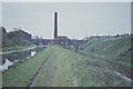
Canals at Smethwick
Looking south-east, the new main line (right) is several metres lower than the old main line (left)
Image: © Andrew Longton
Taken: 14 May 1991
0.24 miles