IMAGES TAKEN NEAR TO
Francis Road, SMETHWICK, B67 7HU
Introduction
This page details the photographs taken nearby to Francis Road, B67 7HU by members of the Geograph project.
The Geograph project started in 2005 with the aim of publishing, organising and preserving representative images for every square kilometre of Great Britain, Ireland and the Isle of Man.

There are currently over 7.5m images from over14,400 individuals and you can help contribute to the project by visiting https://www.geograph.org.uk
Image Map
Images are licensed for reuse under creativecommons.org/licenses/by-sa/2.0
Notes
- Clicking on the map will re-center to the selected point.
- The higher the marker number, the further away the image location is from the centre of the postcode.
Image Listing (15 Images Found)
Images are licensed for reuse under creativecommons.org/licenses/by-sa/2.0
Image
Details
Distance
3
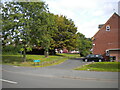
Service road and green space off Manor Road, Londonderry
Image: © Richard Vince
Taken: 11 Sep 2021
0.12 miles
4
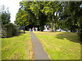
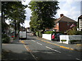
Footpath off Awefields Crescent, Londonderry
Cutting off the corner between Pear Tree Road (behind the photographer) and Londonderry Lane.
Image: © Richard Vince
Taken: 11 Sep 2021
0.13 miles
5
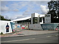
Sandwell Aquatics Centre site entrance, Londonderry
Off Londonderry Lane, with the shell of the building at least looking substantially complete.
Image: © Richard Vince
Taken: 11 Sep 2021
0.13 miles
6
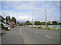
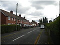
Manor Road, Londonderry
Looking towards Rood End from the junction with Shakespeare Road. The fence on the right obscures the view of a set of allotments.
Image: © Richard Vince
Taken: 11 Sep 2021
0.13 miles
7
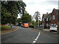
East side of Awefields Crescent, Londonderry
Looking towards Londonderry Lane from the junction with Yew Tree Road.
Image: © Richard Vince
Taken: 11 Sep 2021
0.13 miles
8
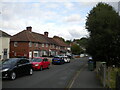
Shakespeare Road, Londonderry
Off Manor Road.
Image: © Richard Vince
Taken: 11 Sep 2021
0.14 miles
9
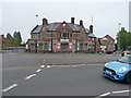
The (former) Queen's Head in Londonderry
Despite fears some years ago regarding demolition Image, the building appears to have survived pretty much intact, and is now a veterinary practice.
Image: © Richard Law
Taken: 20 May 2019
0.18 miles
10
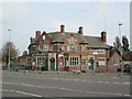
The Queen's Head, Londonderry Lane
A former pub, now fenced off. A local newspaper reported in February 2015 that there were plans to demolish the pub, damaged by fire in May 2014, and build houses on the site.
Image: © David Weston
Taken: 11 Oct 2015
0.18 miles