IMAGES TAKEN NEAR TO
Galton Road, SMETHWICK, B67 5JT
Introduction
This page details the photographs taken nearby to Galton Road, B67 5JT by members of the Geograph project.
The Geograph project started in 2005 with the aim of publishing, organising and preserving representative images for every square kilometre of Great Britain, Ireland and the Isle of Man.

There are currently over 7.5m images from over14,400 individuals and you can help contribute to the project by visiting https://www.geograph.org.uk
Image Map
Images are licensed for reuse under creativecommons.org/licenses/by-sa/2.0
Notes
- Clicking on the map will re-center to the selected point.
- The higher the marker number, the further away the image location is from the centre of the postcode.
Image Listing (10 Images Found)
Images are licensed for reuse under creativecommons.org/licenses/by-sa/2.0
Image
Details
Distance
1
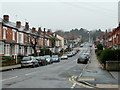
Upper St. Mary's Road, Warley
Early twentieth century housing in Smethwick.
The trees at the end are in Warley Park.
Image: © Jonathan Billinger
Taken: 15 Feb 2010
0.12 miles
2
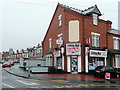
Upper Saint Mary's News
Corner shop on the junction of Wigorn Road and Upper St. Mary's Road, Warley.
Image: © Jonathan Billinger
Taken: 15 Feb 2010
0.14 miles
3
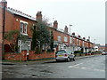
Long Hyde Road
Viewed from Wigorn Road on a damp February morning.
Image: © Jonathan Billinger
Taken: 15 Feb 2010
0.14 miles
4

Warley Park
http://www.warleywoods.org.uk/about-the-park/
Image: © Stephen Rogerson
Taken: 5 Jun 2014
0.20 miles
5
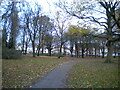
Footpath in Lightwoods Park, Bearwood
Looking towards Lightwoods Hill.
Image: © Richard Vince
Taken: 3 Dec 2022
0.21 miles
6
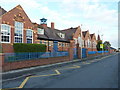
Abbey Junior School, Warley Woods
A carved plaque high on the tower overlooking the main entrance at the far end tells us that the Abbey Road Schools here were built for the Oldbury Urban District Council in 1909, designed by William F Edwards, and erected by W Jackson.
Image: © Richard Law
Taken: 2 Oct 2019
0.23 miles
7

Lightwoods Park
Now part of the borough of Sandwell this park used to be in the Bearwood area of Smethwick. The houses in the distance are amongst the streets in which Julie Walters (actress) and Christine McVie (musician with Fleetwood Mac) once lived.
Image: © Row17
Taken: 20 Mar 2009
0.23 miles
8
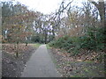
Footpath into Warley Woods, Bearwood
Off Lightwoods Hill.
Image: © Richard Vince
Taken: 3 Dec 2022
0.23 miles
9
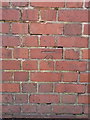
OS benchmark - Warley Woods, by Abbey Junior School
Cut in 1956 and levelled at 201.759m above Ordnance Datum Newlyn, this mark is pretty much as good as the day it was created.
Image: © Richard Law
Taken: 2 Oct 2019
0.24 miles
10

Lightwoods Park, Bearwood
Looking south-west from Galton Road
Image: © Noisar
Taken: 21 Jun 2019
0.25 miles