IMAGES TAKEN NEAR TO
Monmouth Road, SMETHWICK, B67 5EF
Introduction
This page details the photographs taken nearby to Monmouth Road, B67 5EF by members of the Geograph project.
The Geograph project started in 2005 with the aim of publishing, organising and preserving representative images for every square kilometre of Great Britain, Ireland and the Isle of Man.

There are currently over 7.5m images from over14,400 individuals and you can help contribute to the project by visiting https://www.geograph.org.uk
Image Map
Images are licensed for reuse under creativecommons.org/licenses/by-sa/2.0
Notes
- Clicking on the map will re-center to the selected point.
- The higher the marker number, the further away the image location is from the centre of the postcode.
Image Listing (8 Images Found)
Images are licensed for reuse under creativecommons.org/licenses/by-sa/2.0
Image
Details
Distance
1

Miller & Carter Steakhouse on Hagley Road West
Image: © JThomas
Taken: 8 Jun 2019
0.11 miles

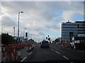
3
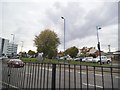
Hagley Road Junction
The view of the A456 and the Wolverhampton Road (A4123) in Warley.
Image: © Gordon Griffiths
Taken: 13 Sep 2015
0.18 miles
4
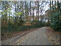
Footpath through Warley Woods
The fence on the left separates the golf course from the public park.
Image: © Richard Vince
Taken: 3 Dec 2022
0.18 miles
5
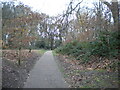
Footpath into Warley Woods, Bearwood
Off Lightwoods Hill.
Image: © Richard Vince
Taken: 3 Dec 2022
0.19 miles
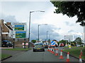
6
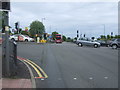
Hagley Road West junction with Wolverhampton Road
Busy junction of the A456 and the A4123.
Image: © JThomas
Taken: 8 Jun 2019
0.21 miles
7
Hagley Road West A456, Wolverhampton Road South Junction Roadworks
Image: © Roy Hughes
Taken: 7 Dec 2011
0.21 miles
8
A4123 Wolverhampton Road South, A456 Hagley Road West Junction
Image: © Roy Hughes
Taken: 8 Jun 2011
0.22 miles