IMAGES TAKEN NEAR TO
Holte Road, BIRMINGHAM, B6 6RP
Introduction
This page details the photographs taken nearby to Holte Road, B6 6RP by members of the Geograph project.
The Geograph project started in 2005 with the aim of publishing, organising and preserving representative images for every square kilometre of Great Britain, Ireland and the Isle of Man.

There are currently over 7.5m images from over14,400 individuals and you can help contribute to the project by visiting https://www.geograph.org.uk
Image Map (Loading...)


Getting Data...Please wait
Leaflet Map data © OpenStreetMap
Images are licensed for reuse under creativecommons.org/licenses/by-sa/2.0
Notes
- Clicking on the map will re-center to the selected point.
- The higher the marker number, the further away the image location is from the centre of the postcode.
Image Listing (125 Images Found)
Images are licensed for reuse under creativecommons.org/licenses/by-sa/2.0
Image
Details
Distance
1
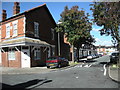
Aston-Charles Road
Looking from Yew Tree Road.
Image: © Ian Rob
Taken: 29 Aug 2010
0.02 miles
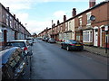
2
Holte Road, Aston
Post-Victorian terraced housing in Aston, Birmingham.
Image: © Richard Law
Taken: 1 Feb 2017
0.02 miles

4
Witton Lane (B4137)
Approaching Villa Park.
Image: © JThomas
Taken: 18 Apr 2013
0.04 miles
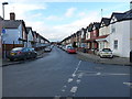
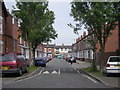
5
Yew Tree Road, Aston
Terraced housing from the early 20th century, to the north side of Aston.
Image: © Richard Law
Taken: 1 Feb 2017
0.05 miles
6

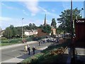
Aston-Villa Park
Supporters make their way out of the ground after the local derby game against West Bromwich Albion.
Image: © Ian Rob
Taken: 30 Sep 2012
0.07 miles
9
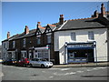
Aston-Serpentine Road
Shop and houses at the junction with Holte Road.
Image: © Ian Rob
Taken: 29 Aug 2010
0.08 miles
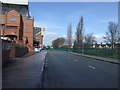
10
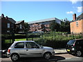
Aston-Witton Gardens
Gardens which run down Witton Lane alongside Villa Park. The land was previously terraced houses which were demolished to allow the expansion of the Football Ground.
Image: © Ian Rob
Taken: 29 Aug 2010
0.08 miles