IMAGES TAKEN NEAR TO
Montague Road, SMETHWICK, B66 4PQ
Introduction
This page details the photographs taken nearby to Montague Road, B66 4PQ by members of the Geograph project.
The Geograph project started in 2005 with the aim of publishing, organising and preserving representative images for every square kilometre of Great Britain, Ireland and the Isle of Man.

There are currently over 7.5m images from over14,400 individuals and you can help contribute to the project by visiting https://www.geograph.org.uk
Image Map
Images are licensed for reuse under creativecommons.org/licenses/by-sa/2.0
Notes
- Clicking on the map will re-center to the selected point.
- The higher the marker number, the further away the image location is from the centre of the postcode.
Image Listing (30 Images Found)
Images are licensed for reuse under creativecommons.org/licenses/by-sa/2.0
Image
Details
Distance
1
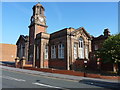
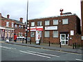
Cape House, Smethwick
Cape House was the local branch in Smethwick of the Birmingham General Dispensary, a charitable foundation organisation which pre-dates the National Health Service by some considerable margin, and provided health care to the poor of Birmingham for many years (the charity itself closed in 2001). This particular building, which dates from 1907, was Grade II listed https://britishlistedbuildings.co.uk/101380114-cape-house-soho-and-victoria-ward#.XRB11IhKhPY & https://historicengland.org.uk/listing/the-list/list-entry/1380114 in 2000.
Image: © Richard Law
Taken: 20 May 2019
0.06 miles
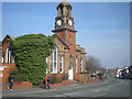
3

Cape House, Smethwick
Cape House was the local branch in Smethwick of the Birmingham General Dispensary, a forerunner of the NHS. Building now Grade II listed.
Image: © JThomas
Taken: 22 Aug 2019
0.07 miles
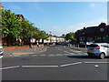
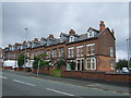
5
Cape Hill
Cape Hill is the name of both this road and the surrounding area, part of Smethwick. This is looking down from the junction with Montague Road.
Image: © Stephen McKay
Taken: 17 May 2018
0.09 miles
6
Post Office on Cape Hill (A4092), Smethwick
Image: © JThomas
Taken: 22 Aug 2019
0.09 miles
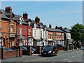
9
The former United Counties Bank building, Smethwick
Later housed a branch of Barclays Bank which has now closed.
Image: © JThomas
Taken: 22 Aug 2019
0.15 miles
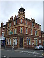
10
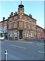
The former United Counties Bank building, Smethwick
On the corner of Cape Hill with Salisbury Road, this rather fine building stands as a bit of a landmark. United Counties Bank was a regional name adopted in 1907, following the merger of the Birmingham District & Counties Banking Company with the Bradford Old Bank. It was later acquired by what was to become the Barclays Banking Group. Aside from this branch, it had operations in Cradley Heath and Wolverhampton that I can find referenced; there were certainly many others.
Image: © Richard Law
Taken: 20 May 2019
0.15 miles