IMAGES TAKEN NEAR TO
Waterloo Road, SMETHWICK, B66 4ND
Introduction
This page details the photographs taken nearby to Waterloo Road, B66 4ND by members of the Geograph project.
The Geograph project started in 2005 with the aim of publishing, organising and preserving representative images for every square kilometre of Great Britain, Ireland and the Isle of Man.

There are currently over 7.5m images from over14,400 individuals and you can help contribute to the project by visiting https://www.geograph.org.uk
Image Map
Images are licensed for reuse under creativecommons.org/licenses/by-sa/2.0
Notes
- Clicking on the map will re-center to the selected point.
- The higher the marker number, the further away the image location is from the centre of the postcode.
Image Listing (18 Images Found)
Images are licensed for reuse under creativecommons.org/licenses/by-sa/2.0
Image
Details
Distance
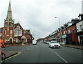
2
A4092 Waterloo Road Smethwick at Grange Road island
Image: © Roy Hughes
Taken: 31 Jul 2021
0.13 miles
4
Hadley Stadium
This stadium beside Waterloo Road has one of the country's first synthetic race tracks. http://www.runtrackdir.com/details.asp?track=smethwick
Image: © David Stowell
Taken: 2 Jul 2006
0.16 miles
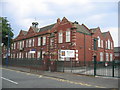
6
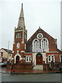
Gurdwara Nanaksar, Birmingham
This Sikh place of worship uses an ex-Methodist church on Waterloo Road, Smethwick.
Image: © Jonathan Billinger
Taken: 15 Feb 2010
0.16 miles
10
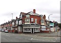
A curry house in Bearwood, Birmingham
Image: © Neil Theasby
Taken: 21 Jul 2013
0.19 miles