IMAGES TAKEN NEAR TO
Sandon Road, SMETHWICK, B66 4AA
Introduction
This page details the photographs taken nearby to Sandon Road, B66 4AA by members of the Geograph project.
The Geograph project started in 2005 with the aim of publishing, organising and preserving representative images for every square kilometre of Great Britain, Ireland and the Isle of Man.

There are currently over 7.5m images from over14,400 individuals and you can help contribute to the project by visiting https://www.geograph.org.uk
Image Map
Images are licensed for reuse under creativecommons.org/licenses/by-sa/2.0
Notes
- Clicking on the map will re-center to the selected point.
- The higher the marker number, the further away the image location is from the centre of the postcode.
Image Listing (27 Images Found)
Images are licensed for reuse under creativecommons.org/licenses/by-sa/2.0
Image
Details
Distance
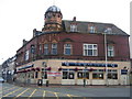
2
"The Bear Tavern" in Bearwood, Birmingham
Image: © Neil Theasby
Taken: 21 Jul 2013
0.04 miles
3
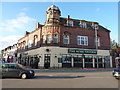
The Bear Tavern in Bearwood
A landmark building in the middle of Bearwood; a sign on the wall suggests that the name doesn't necessarily come from "wood with bears" but more likely the Old English words 'bearu' and 'wudu', meaning Grove Wood; this would have been a place of pig grazing in the Middle Ages. That doesn't preclude the survival of bears in the area at least until Roman times, as the area was densely forested at that time.
Image: © Richard Law
Taken: 2 Oct 2019
0.05 miles
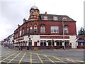
5
The Bear in Bearwood
The Bear Inn in the centre of Bearwood on the corner of Bearwood Road and Three Shires Oak Road (to the right). Compare this local landmark with older pictures on http://www.virtualbrum.co.uk/warley.htm
Image: © David Stowell
Taken: 2 Jul 2006
0.07 miles
6
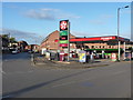
Texaco fuel station in Bearwood
Unleaded is currently £1.249 a litre, with diesel £1.299
Image: © Richard Law
Taken: 2 Oct 2019
0.07 miles
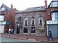
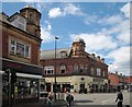
8
The Midland (1), 526-528 Bearwood Road, Bearwood
The building was designed for the former Midland Bank or possibly for one of the banks it absorbed. It later became a branch of the HSBC Bank. By 2012 it had closed and in July 2014 Black Country Ales re-opened it as one of their small chain of real ale pubs. The interior is impressive and the conversion works surprisingly well.
Image
Image
Image: © P L Chadwick
Taken: 24 Jan 2016
0.08 miles
9
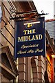
The Midland (2) - sign, 526-528 Bearwood Road, Bearwood
The sign is typical of those used by Black Country Ales with their two windmills logo at the top.
Image
Image
Image: © P L Chadwick
Taken: 24 Jan 2016
0.08 miles
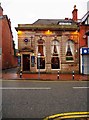
10
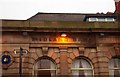
The Midland (3) - detail, 526-528 Bearwood Road, Bearwood
When the building was a branch of the former Midland Bank, the bank's name was at the top of the ground floor. Following acquisition by HSBC Bank it would have been rebranded around 1999. When Black Country Ales opened a public house in the building in 2014, and named it The Midland, they had the old Midland Bank sign repainted. A close look reveals that the letters are not actually fully in alignment with the old. In the bottom left of this picture the two windmills logo of Black Country Ales can be seen.
Image
Image
Image: © P L Chadwick
Taken: 24 Jan 2016
0.08 miles