IMAGES TAKEN NEAR TO
Scribbans Close, SMETHWICK, B66 3PS
Introduction
This page details the photographs taken nearby to Scribbans Close, B66 3PS by members of the Geograph project.
The Geograph project started in 2005 with the aim of publishing, organising and preserving representative images for every square kilometre of Great Britain, Ireland and the Isle of Man.

There are currently over 7.5m images from over14,400 individuals and you can help contribute to the project by visiting https://www.geograph.org.uk
Image Map
Images are licensed for reuse under creativecommons.org/licenses/by-sa/2.0
Notes
- Clicking on the map will re-center to the selected point.
- The higher the marker number, the further away the image location is from the centre of the postcode.
Image Listing (32 Images Found)
Images are licensed for reuse under creativecommons.org/licenses/by-sa/2.0
Image
Details
Distance
1
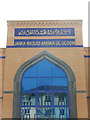
Jamia Masjid Anwar-Ul-Uloom
This is the front of Smethwick's impressive new mosque, still under construction, on Windmill Lane. The Jamia Masjid Anwar-Ul-Uloom Trust website makes this observation: 'The need of a mosque in Smethwick to represent the Muslims is paramount; around us in Smethwick other faiths have their places of worship in the form of Gurdwaras, Temples, Synagogues and Churches. Seeing this we propose the project of JAMIA MASJID ANWAR UL ULOOM to the public of Smethwick'. The mosque's external architecture is described as 'on a theme of a purpose built Mosque' with four minarets, a dome, window arches and religious calligraphy. The style is in marked contrast with the building opposite, reflected in the window.
Image: © Stephen McKay
Taken: 17 May 2018
0.04 miles
2
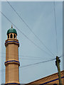
Jamia Masjid Anwar-Ul-Uloom
One of the minarets on Smethwick's new mosque towers over Trafalgar Road. See Image for more details.
Image: © Stephen McKay
Taken: 17 May 2018
0.05 miles
3
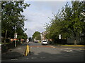
Croxall Way, Smethwick
Off Ballot Street, parallel with Windmill Lane.
Image: © Richard Vince
Taken: 11 Sep 2021
0.05 miles
4
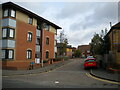
Mill Drive, Smethwick
A residential cul de sac off Ballot Street.
Image: © Richard Vince
Taken: 11 Sep 2021
0.05 miles
5
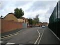
Suffrage Street, Smethwick
Off Windmill Lane. The next road north off this side of Windmill Lane is Ballot Street, giving the appearance of one of the odder themed names for roads.
Image: © Richard Vince
Taken: 11 Sep 2021
0.05 miles
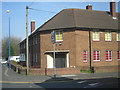
7
Smethwick Gospel Hall
On Windmill Lane.
Image: © Richard Vince
Taken: 11 Sep 2021
0.10 miles
8
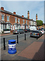
Salisbury Road, Cape Hill
The litter bin announces 'Smethwick Pride' adding a bright touch to this street of traditional terraced houses. The towers belong to Smethwick's new mosque currently under construction.
Image: © Stephen McKay
Taken: 17 May 2018
0.10 miles
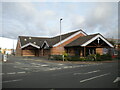
9
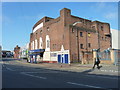
The former Mecca Bingo Hall
A potted, and slightly personalised, history of the building is at Image, but it was originally built in the late 1920s as The Rink Cinema (in honour of a former icerink on the same site). It changed to The Gaumont, and then a Mecca Bingo venue from the mid 1960s, and was Grade II listed https://britishlistedbuildings.co.uk/101384947-mecca-bingo-club-soho-and-victoria-ward#.XRMRuOhKhPY & https://historicengland.org.uk/listing/the-list/list-entry/1384947 in 2000. As the image linked above suggests, it's now available for hire, social events, weddings, discos, children's parties etc.
Image: © Richard Law
Taken: 20 May 2019
0.15 miles
10
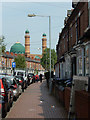
Salisbury Road, Cape Hill
Salisbury Road connects Cape Hill with Trafalgar Road, consisting of terraced houses typical of the area. Looming over the houses is Jamia Masjid Anwar Ul Uloom a new mosque, currently under construction.
Image: © Stephen McKay
Taken: 17 May 2018
0.16 miles