IMAGES TAKEN NEAR TO
High Street, SMETHWICK, B66 3PB
Introduction
This page details the photographs taken nearby to High Street, B66 3PB by members of the Geograph project.
The Geograph project started in 2005 with the aim of publishing, organising and preserving representative images for every square kilometre of Great Britain, Ireland and the Isle of Man.

There are currently over 7.5m images from over14,400 individuals and you can help contribute to the project by visiting https://www.geograph.org.uk
Image Map
Images are licensed for reuse under creativecommons.org/licenses/by-sa/2.0
Notes
- Clicking on the map will re-center to the selected point.
- The higher the marker number, the further away the image location is from the centre of the postcode.
Image Listing (35 Images Found)
Images are licensed for reuse under creativecommons.org/licenses/by-sa/2.0
Image
Details
Distance
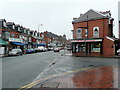
1
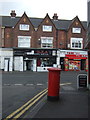
Shops on Waterloo Road, A4092, Smethwick
Showing position of Postbox No. B66 546.
See Image] for postbox.
Image: © JThomas
Taken: 22 Aug 2019
0.10 miles
2
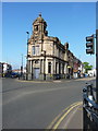
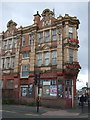
The former Lloyds Bank building, Smethwick
Built in 1907 in the angle of High Street and Waterloo Road, the one-time Lloyds Bank was Grade II listed https://britishlistedbuildings.co.uk/101380353-former-lloyds-bank-soho-and-victoria-ward#.XRBwd4hKhPY & https://historicengland.org.uk/listing/the-list/list-entry/1380353 in 2000. Externally the building remains reasonably intact, but the interior fittings of the bank have been removed, unfortunately.
Image: © Richard Law
Taken: 20 May 2019
0.10 miles
5
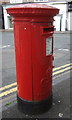
Elizabeth II postbox on Waterloo Road, A4092, Smethwick
Postbox No. B66 546.
See Image] for context.
Image: © JThomas
Taken: 22 Aug 2019
0.11 miles
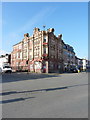
6
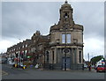
The Sampson Lloyd, Smethwick
The former Lloyds Bank building.
Image: © JThomas
Taken: 22 Aug 2019
0.11 miles
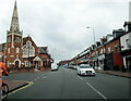
7
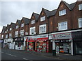
Waterloo Road, Smethwick
Looking north-east from the junction of Sycamore Road towards the town centre.
Image: © Jonathan Billinger
Taken: 15 Feb 2010
0.11 miles
9
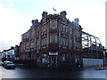
The Waterloo Hotel, Smethwick
A former Mitchells & Butlers M&B pub, which is Grade II* listed.
Image: © JThomas
Taken: 22 Aug 2019
0.12 miles
10
The Waterloo Hotel
Situated in the angle formed by Shireland Road with Waterloo Road, The Waterloo is currently (2019) closed and available to let. It's a former Mitchells & Butlers M&B pub, which was Grade II* listed https://britishlistedbuildings.co.uk/101261644-the-waterloo-hotel-soho-and-victoria-ward#.XRJJ6uhKjcs & https://historicengland.org.uk/listing/the-list/list-entry/1261644 in 1995, as "An exceptionally fine and near- complete example of an Edwardian showpiece public house and commercial hotel which retains its original plan-form and many interior features, including the unusually ornate and complete basement grill room".
Image: © Richard Law
Taken: 20 May 2019
0.13 miles