IMAGES TAKEN NEAR TO
Heath Street Industrial Estate, Abberley Street, SMETHWICK, B66 2QZ
Introduction
This page details the photographs taken nearby to Heath Street Industrial Estate, Abberley Street, B66 2QZ by members of the Geograph project.
The Geograph project started in 2005 with the aim of publishing, organising and preserving representative images for every square kilometre of Great Britain, Ireland and the Isle of Man.

There are currently over 7.5m images from over14,400 individuals and you can help contribute to the project by visiting https://www.geograph.org.uk
Image Map
Images are licensed for reuse under creativecommons.org/licenses/by-sa/2.0
Notes
- Clicking on the map will re-center to the selected point.
- The higher the marker number, the further away the image location is from the centre of the postcode.
Image Listing (74 Images Found)
Images are licensed for reuse under creativecommons.org/licenses/by-sa/2.0
Image
Details
Distance
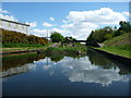
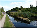
3

Rushes at Winson Green stop
One of several former toll islands on the BCN's New Main Line canal.
Image: © Christine Johnstone
Taken: 4 Sep 2012
0.08 miles
4
Winson Green Stop, New Main Line
A toll island, just west of Winson Green Junction.
Image: © Christine Johnstone
Taken: 10 May 2018
0.08 miles
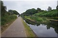
5
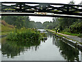
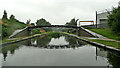
Bridge and former toll site near Winson Green, Birmingham
Close to Winson Green Junction, this is Thomas Telford's "new" main line, looking north-west towards Smethwick and Wolverhampton. The cast iron bridge made by the Horseley Company in Tipton is dated 1848 and is Grade II listed. Telford widened and straightened Brindley's meandering route, and provided towpaths on both sides. The island is all that remains of a canal toll office.
This was a very dull drizzly day. The minor blemish on the image was caused by a small water droplet on the lens.
Interesting alternative view: Image]
Image: © Roger Kidd
Taken: 26 Aug 2010
0.08 miles
6
Toll island on the Main Line
The now-overgrown remains of the Winson Green gauging or toll island. See Image for the same place soon after the octagonal office had been demolished. Toll islands like this were used to constrict the passage of boats through the canal system in such a way that they could be gauged; by being forced to pass right outside the toll booth, they had to pay the levy for carriage of their cargo on the waterway.
Image: © Richard Law
Taken: 20 Aug 2014
0.08 miles
7
Birmingham New Main Line Canal
Turnover bridge near the end of the Soho Loop.
Image: © Ian S
Taken: 25 Jul 2021
0.08 miles
9
Roving bridge just west of the Soho loop entrance
A roving bridge over the Main Line canal, cast in Tipton in 1848 (and presumably built at more or less the same date). It was Grade II listed https://britishlistedbuildings.co.uk/101289686-roving-bridge-over-birminghamwolverhampton-canal-just-west-of-west-soho-loop-entrance-soho-and-victoria-ward#.YpIo6KjMLIU & https://historicengland.org.uk/listing/the-list/list-entry/1289686 in 1982.
Image: © Richard Law
Taken: 25 May 2022
0.09 miles
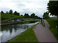
10
Birmingham Canal Navigations near Winson Green in Birmingham
Close to Winson Green Junction, this is Thomas Telford's "new" main line, looking north-west towards Smethwick and Wolverhampton. The cast iron bridge made by the Horseley Company in Tipton is dated 1848 and is Grade II listed. Telford widened and straightened Brindley's meandering route, and provided towpaths on both sides.
This was a very dull drizzly day. The blemish on the image was caused by a small water droplet on the lens.
Image: © Roger Kidd
Taken: 26 Aug 2010
0.09 miles