IMAGES TAKEN NEAR TO
Grove Lane, B66 2QT
Introduction
This page details the photographs taken nearby to Grove Lane, B66 2QT by members of the Geograph project.
The Geograph project started in 2005 with the aim of publishing, organising and preserving representative images for every square kilometre of Great Britain, Ireland and the Isle of Man.

There are currently over 7.5m images from over14,400 individuals and you can help contribute to the project by visiting https://www.geograph.org.uk
Image Map
Images are licensed for reuse under creativecommons.org/licenses/by-sa/2.0
Notes
- Clicking on the map will re-center to the selected point.
- The higher the marker number, the further away the image location is from the centre of the postcode.
Image Listing (37 Images Found)
Images are licensed for reuse under creativecommons.org/licenses/by-sa/2.0
Image
Details
Distance
1
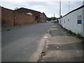
Grove Street, Smethwick
The area is undergoing significant redevelopment; the hoardings on the right mask a large site where Carillion are currently building the new Midland Metropolitan Hospital. This will be a 669-bed, 13-operating theatre facility, providing acute and emergency services for a large part of the West Mids.
Image: © Richard Law
Taken: 26 Jun 2017
0.14 miles

3

OS benchmark - Smethwick, Grove St factory wall
An OS cutmark on the external wall of a works building on the east side of Grove St; originally levelled, probably in 1956, at 139.861m above Ordnance Datyum Newlyn.
Image: © Richard Law
Taken: 26 Jun 2017
0.16 miles
4

Entrance to the Cape Arm
On the Birmingham Canal Navigation.
Image: © Andrew Abbott
Taken: 13 Sep 2022
0.18 miles
5
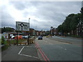
Grove Lane, Smethwick
The A457 approaching a roundabout.
Image: © JThomas
Taken: 22 Aug 2019
0.19 miles
6
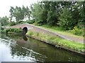
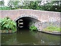
Roving bridge over the entrance to Cape Arm
On the south side of the BCN's New Main Line. Cape Arm was created from a loop of the Old Main Line.
Image: © Christine Johnstone
Taken: 4 Sep 2012
0.19 miles
7
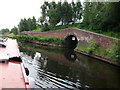
Cape Arm junction, Birmingham Canal Main Line
The Cape Arm was part of the original Birmingham Canal which became a subsidiary loop when Telford's New Main Line was cut in the 1830's. It had its own branch from the centre of the loop which extended as far south as Grove Lane, and served many different factories.
It leaves the New Main Line under the bridge on the right (which is actually a tunnel without a towpath under a canal feeder which runs along the embankment above).
Most unusually, a considerable length of this disused and inaccessible arm is still in water. It can be seen on current aerial photos on Google and Multimap, and can also be seen from Cranford Street bridge, though it cannot be accessed as it does not have a towpath. I assume that it is still used as a source of cooling water by the factories which still line its banks.
The Cranford St end of the Cape Arm was also used as a set for a brief scene in the film 'Take Me High' (1973) in which Cliff Richard arrives at a factory in a hovercraft.
The second bridge which can just be seen in the photograph is the entrance to a former basin which is shown on the OS 1890 map serving the Imperial Wire Mills.
Image: © John Brightley
Taken: 18 Jun 2010
0.19 miles
8
Entrance to the former Cape Arm
On the south side of the BCN's New Main Line.
Image: © Christine Johnstone
Taken: 4 Sep 2012
0.19 miles
9

Birmingham New Main Line Canal
At Cape Arm Bridge.
Image: © Ian S
Taken: 25 Jul 2021
0.19 miles
10

Disused arm, BCN Main Line
Bridges along the towpath leading to mysterious and long disused arms are a feature of much of the BCN network. This is one of two in close proximity, the other leading into the Cape Arm.
Image: © Stephen McKay
Taken: 4 Aug 2014
0.19 miles