IMAGES TAKEN NEAR TO
Middlemore Road, SMETHWICK, B66 2DR
Introduction
This page details the photographs taken nearby to Middlemore Road, B66 2DR by members of the Geograph project.
The Geograph project started in 2005 with the aim of publishing, organising and preserving representative images for every square kilometre of Great Britain, Ireland and the Isle of Man.

There are currently over 7.5m images from over14,400 individuals and you can help contribute to the project by visiting https://www.geograph.org.uk
Image Map
Images are licensed for reuse under creativecommons.org/licenses/by-sa/2.0
Notes
- Clicking on the map will re-center to the selected point.
- The higher the marker number, the further away the image location is from the centre of the postcode.
Image Listing (62 Images Found)
Images are licensed for reuse under creativecommons.org/licenses/by-sa/2.0
Image
Details
Distance
1
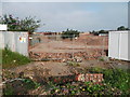
Brindley's Smethwick Locks
The recent clearance of the Evered metals site has revealed the line of Brindley's original Smethwick locks.
This site is soon to be developed for housing as part of Brindley Village.
http://www.pxpwestmidlands.co.uk/brindleyvillageII
Image: © planetearthisblue
Taken: 21 Jul 2012
0.12 miles
2
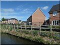
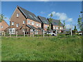
Canalside housing at Hidden Lock, Smethwick
Hidden Lock is the name of the road, as this estate is built on the route of Smethwick Old Locks, which were bypassed in 1790. The photographer is between the Bottom and Middle Smethwick Locks, on the 'bypass' route.
Image: © Christine Johnstone
Taken: 10 May 2022
0.13 miles
3
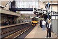
Hawthorns Station
The station is close to the West Bromwich Albion football ground, hence the name
Image: © Bill Payer
Taken: Unknown
0.13 miles
4
Canalside houses at Hidden Lock, Smethwick
Hidden Lock is the name of the road, as this estate is built on the route of Smethwick Old Locks, which were bypassed in 1790. The photographer is at Smethwick Bottom Lock, on the 'bypass' route.
Image: © Christine Johnstone
Taken: 10 May 2022
0.13 miles
5
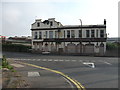
The New Navigation, Smethwick
I used to collect pallets of flour from a small business near here and I sometimes took a camera out in the lorry with me. This was taken seven years ago and the place hasn't changed much in the meantime, apart from the lower windows being boarded up. The name refers to Thomas Telford's canal, which replaced James Brindley's earlier Birminghmam - Wolverhampton main line in 1829.
Image: © John Winder
Taken: 22 Jun 2007
0.14 miles
6
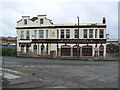
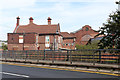
The New Navigation
This former Banks' pub is still occupied on the first floor
Image: © planetearthisblue
Taken: 21 Jul 2012
0.14 miles
7
Birmingham Canal Navigations - Old Main Line, Smethwick
This is the bottom of three locks that raise the canal to the summit level through Smethwick. The bridge is labelled Pope Bridge. The buildings beyond are former tramways offices and the tramway power station.
Image: © Chris Allen
Taken: 14 Sep 2019
0.15 miles
8

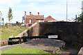
Smethwick Bottom Lock, Birmingham Canal
The bottom of the three locks raising the Old Line of the canal from the Birmingham to the Wolverhampton level. The lock is Listed Grade II.
Image: © Alan Murray-Rust
Taken: 5 Sep 2019
0.15 miles
9
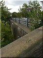
Rivet bench mark, Pope's Bridge
On the parapet alongside the towpath ramp leading up from the canal to Rolfe Lane.
Image: © Alan Murray-Rust
Taken: 5 Sep 2019
0.15 miles
10
Tramway offices and power station, Smethwick
Apparently the pub-like building in the foreground was offices for the tram company and the larger building beyond was the power station generating electricity for the trams. It is now owned by a window company. This information came from our guide on a walking tour of the canals from New Smethwick Pumping Station to the Boulton & Watt engine foundations in Bridge Street. Some of the educational material passed around at the latter site included one of my Geograph images.
Image: © Chris Allen
Taken: 14 Sep 2019
0.15 miles