IMAGES TAKEN NEAR TO
Chance Drive, SMETHWICK, B66 1TT
Introduction
This page details the photographs taken nearby to Chance Drive, B66 1TT by members of the Geograph project.
The Geograph project started in 2005 with the aim of publishing, organising and preserving representative images for every square kilometre of Great Britain, Ireland and the Isle of Man.

There are currently over 7.5m images from over14,400 individuals and you can help contribute to the project by visiting https://www.geograph.org.uk
Image Map
Images are licensed for reuse under creativecommons.org/licenses/by-sa/2.0
Notes
- Clicking on the map will re-center to the selected point.
- The higher the marker number, the further away the image location is from the centre of the postcode.
Image Listing (79 Images Found)
Images are licensed for reuse under creativecommons.org/licenses/by-sa/2.0
Image
Details
Distance
1
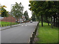
Grenville Drive
Surprisingly quiet, despite being situated between the A457 and the main line NW from Birmingham New Street which is in a cutting to the right of the railings.
Image: © Peter Whatley
Taken: 9 Oct 2008
0.01 miles
2
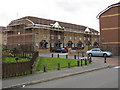
Melrose Place flats
One of several identical blocks of modern flats between the A457 and main railway line between Birmingham and Wolverhampton.
Image: © Peter Whatley
Taken: 9 Oct 2008
0.05 miles
3

Cyclists on the New Main Line towpath
Here part of the national cycle route no. 81.
Image: © Christine Johnstone
Taken: 10 May 2018
0.05 miles
4
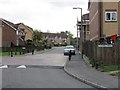
Shetland Drive
Despite the sign on the right, ahead is Shetland Drive, though that's not what the street sign says...
Image: © Peter Whatley
Taken: 9 Oct 2008
0.06 miles
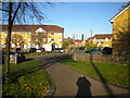
5

Footpath off Oldbury Road, West Smethwick
Leading to Chance Drive via the ends of Orchid Close and Melrose Place.
Image: © Richard Vince
Taken: 19 Nov 2022
0.09 miles
6
Footpath to Orchid Close, West Smethwick
Off Oldbury Road. The Kenrick Park flats in West Bromwich are visible in the distance.
Image: © Richard Vince
Taken: 19 Nov 2022
0.10 miles
7
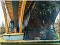
Spon Lane Bridge, Smethwick
Taken from the Birmingham Canal towpath. This bridge carries A4031 Spon Lane; initially a rather narrow road which was widened with the adjoining bridge on the left in the 1920s (exact date unknown, a plaque exists on the bridge deck, according to Street View, but I did not pass it at the time). The early concrete arch design of the newer bridge provides a jarring contrast from the monstrous filth of the original bridge, as impressive as it is.
Image: © Oliver Mills
Taken: 22 Feb 2022
0.10 miles
8
Canal boat Jubilee Golden
Birmingham New Main Line Canal at Spon Lane Bridge.
Image: © Ian S
Taken: 25 Jul 2021
0.11 miles
9

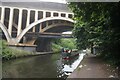
Spon Lane Bridge, Smethwick
Birmingham Canal Navigations (new main line) to Wolverhampton. This is Thomas Telford's shorter route, constructed between 1822 and 1838 to replace Brindley's original 1769 contour hugging line.
Image: © Roger D Kidd
Taken: 26 Aug 2010
0.11 miles
10
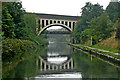
Spon Lane Station Bridge near Oldbury, Sandwell
The bridge carries the A4031 Spon Lane South. The station was past the bridge, off to the left but closed in 1964 and no longer exists.
This is the Birmingham Canal Navigations (new main line) to Wolverhampton. It is Thomas Telford's shorter route, constructed between 1824 and 1838 to replace Brindley's original 1769 contour hugging line (about 150 metres off to the right).
Image: © Roger Kidd
Taken: 26 Aug 2010
0.11 miles