IMAGES TAKEN NEAR TO
Lonsdale Road, SMETHWICK, B66 1QU
Introduction
This page details the photographs taken nearby to Lonsdale Road, B66 1QU by members of the Geograph project.
The Geograph project started in 2005 with the aim of publishing, organising and preserving representative images for every square kilometre of Great Britain, Ireland and the Isle of Man.

There are currently over 7.5m images from over14,400 individuals and you can help contribute to the project by visiting https://www.geograph.org.uk
Image Map
Images are licensed for reuse under creativecommons.org/licenses/by-sa/2.0
Notes
- Clicking on the map will re-center to the selected point.
- The higher the marker number, the further away the image location is from the centre of the postcode.
Image Listing (15 Images Found)
Images are licensed for reuse under creativecommons.org/licenses/by-sa/2.0
Image
Details
Distance
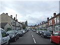
4
The Ivy Bush, Smethwick
A pub between Oldbury and Smethwick.
Image: © David Weston
Taken: 11 Oct 2015
0.07 miles
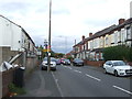
5
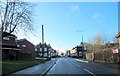
B4169 St Paul's Road West Smethwick Crossroads at The Ivy Bush
Image: © Roy Hughes
Taken: 1 Jan 2018
0.07 miles
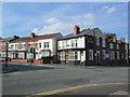
6
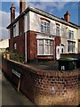
Malcolm X was here: corner of Marshall Street and West Park Road, Smethwick
Since 2012 the house on the corner of Park Road and Marshall Street, Smethwick, has carried a blue plaque, which reads:
Nubian Jak Community Trust
Malcolm X
1925-1965
International civil rights campaigner. Advocated desegregated housing in Smethwick with his visit to Marshall Street in 1965.
Recognize
Sandwell MBC
African Caribbean Self Help Organisation
Indian Workers Association (GB)
Sandwell MBC (Metropolitan Borough Council) is the successor to the County Borough of Smethwick, which at the time of Malcolm X's visit, was proposing to compulsorily purchase every house on Marshall Street to let to white people only. The previous year, the Conservative candidate Peter Griffiths had won the parliamentary seat on an openly racist election slogan and a policy platform of racial segregation. Malcolm X, who was on a tour of Europe and speaking at Birmingham University, was invited by the Indian Workers' Association to visit Smethwick, where he spoke to local people and experienced local conditions, including being excluded from a pub which operated a whites-only 'colour bar' policy: see Image
Malcolm X was assassinated nine days after the visit, shortly after his return to the USA. The council subsequently abandoned its segregationist policy; Marshall Street is now an integrated, multicultural street. See the blog of Verso Books https://www.versobooks.com/en-gb/blogs/news/5046-malcolm-x-and-the-midlands for an account of the visit, also the site of the Nubian Jak Trust https://nubianjak.com/malcolm-x-plaque-february-2012/ .
Image: © A J Paxton
Taken: 15 Apr 2023
0.10 miles
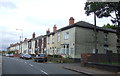
7
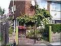
Cottage Garden.
A property in West End Avenue Smethwick..
Image: © David Taylor
Taken: 18 Jul 2008
0.11 miles
9
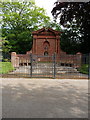
The Memorial to James Chance, West Smethwick Park
This memorial to a Victorian entrepreneur, a director of and partner in the local company Chance Brothers & Co in Smethwick and Oldbury, was erected around 1900, and Grade II listed https://britishlistedbuildings.co.uk/101077101-memorial-to-james-chance-in-west-smethwick-park-st-pauls-ward#.XRUqDuhKjcs & https://historicengland.org.uk/listing/the-list/list-entry/1077101 in 1987. He gifted West Smethwick Park to the people of the area, having purchased the land, laid the park out (probably not personally) and opened it in autumn 1895.
Image: © Richard Law
Taken: 20 May 2019
0.13 miles
10
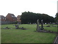
Oldbury Cemetery
St Pauls Road, West Smethwick.
Image: © JThomas
Taken: 22 Aug 2019
0.15 miles