IMAGES TAKEN NEAR TO
Tram Way, Oldbury Road, SMETHWICK, B66 1NR
Introduction
This page details the photographs taken nearby to Tram Way, Oldbury Road, B66 1NR by members of the Geograph project.
The Geograph project started in 2005 with the aim of publishing, organising and preserving representative images for every square kilometre of Great Britain, Ireland and the Isle of Man.

There are currently over 7.5m images from over14,400 individuals and you can help contribute to the project by visiting https://www.geograph.org.uk
Image Map
Images are licensed for reuse under creativecommons.org/licenses/by-sa/2.0
Notes
- Clicking on the map will re-center to the selected point.
- The higher the marker number, the further away the image location is from the centre of the postcode.
Image Listing (77 Images Found)
Images are licensed for reuse under creativecommons.org/licenses/by-sa/2.0
Image
Details
Distance
1
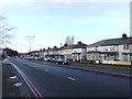
Crystal Drive, Sandwell Business Park
Image: © Chris Whippet
Taken: 21 Dec 2013
0.07 miles
6
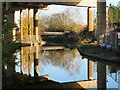
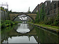
Canal and motorway, Oldbury
The Birmingham Canal Navigations (old main line) looping under the M5 motorway. The lattice bridge in the distance is not accessible.
Image: © Chris Allen
Taken: 11 Nov 2023
0.21 miles
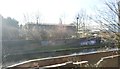
8
Birmingham Old Main Line Canal and the M5
Seen at the Oldbury Viaduct towards the end of the lengthy repairs to the motorway. The Old Main Line was built under the direction of James Brindley in 1769-72. It is intimately entwined with the M5 for a considerable length through this area.
Image: © Chris Allen
Taken: 12 Feb 2020
0.21 miles
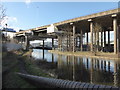
9
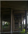
Under the M5 viaduct, seen from the railway
From a passing train, the view along under the M5 viaduct includes in the middle distance the Old Main Line of the Birmingham Canal.
Image: © Christopher Hilton
Taken: 9 Jun 2016
0.22 miles
10
Canal bridges near Smethwick, Sandwell
Looking west on a very dull morning, this is the Birmingham Canal Navigations (new main line) to Wolverhampton. It is Thomas Telford's shorter route, constructed between 1824 and 1838 to replace Brindley's original 1769 contour hugging line (off to the right).
The view is from near Chance's Bridge, formerly serving glass factories, but now redundant and overgrown. (Chance Brothers opened in 1824 and finally stopped working in Smethwick by 1976. In 1933 they used their optical equipment to search for signs of life on Mars. Part of their derelict works is on the right).
The next bridge ahead is Hartley Bridge, similarly disused, which also served Chance's Glassworks.
Beyond that are the aqueduct carrying Brindley's old main line towards Oldbury, and the high structure carrying the M5 motorway.
Image: © Roger Kidd
Taken: 26 Aug 2010
0.22 miles