IMAGES TAKEN NEAR TO
High Street, SMETHWICK, B66 1DU
Introduction
This page details the photographs taken nearby to High Street, B66 1DU by members of the Geograph project.
The Geograph project started in 2005 with the aim of publishing, organising and preserving representative images for every square kilometre of Great Britain, Ireland and the Isle of Man.

There are currently over 7.5m images from over14,400 individuals and you can help contribute to the project by visiting https://www.geograph.org.uk
Image Map
Images are licensed for reuse under creativecommons.org/licenses/by-sa/2.0
Notes
- Clicking on the map will re-center to the selected point.
- The higher the marker number, the further away the image location is from the centre of the postcode.
Image Listing (121 Images Found)
Images are licensed for reuse under creativecommons.org/licenses/by-sa/2.0
Image
Details
Distance
1
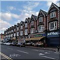
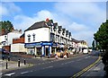
26-50 High Street, Smethwick
This terrace of shops with living space above was built in 1904. The row of gable-ends facing the street and adorned with bargeboards makes a very striking show; the end houses at the street corners are canted (angled) with elaborate pediments topping the facades, and one just can be seen at the far left. See the Smethwick Town Centre Appraisal document at the Sandwell Council site https://www.sandwell.gov.uk/downloads/file/4061/smethwick_town_centre_character_appraisal .
Image: © A J Paxton
Taken: 15 Apr 2023
0.00 miles
2
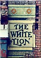
The old White Lion
Taken during the demolition of one side of the road for the construction of the modern dual carriageway through Smethwick.
Image: © Patrick Mackie
Taken: Unknown
0.01 miles
4
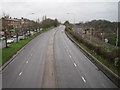
Tollhouse Way and Birmingham-Wolverhampton railway, Smethwick
Image: © Nigel Thompson
Taken: 9 Jan 2016
0.05 miles
5
Billinghams Shoes, 22 High Street
Established 120 years ago, in 1890, P Billingham & Sons is an independent local shoe shop. There is a wide variety of businesses in Smethwick, including many run by members of the various local Asian communities, including at least one pub.
Image: © P L Chadwick
Taken: 16 Aug 2010
0.05 miles
6
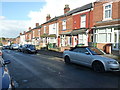
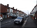
Terraced housing on Dibble Road, Smethwick
Image: © Richard Law
Taken: 11 Aug 2014
0.05 miles
7
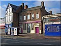
Smethwick Asian Funerals, 66 High Street
The building is used by a funeral directors business. Originally it was a bank, and then used by a playgroup.
Image: © P L Chadwick
Taken: 16 Aug 2010
0.05 miles
8
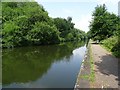
Telford's Birmingham Canal Navigation
The Birmingham Canal Navigation was cut by Thomas Telford at a lower level than the existing canal to avoid the Smethwick Summit.
Image: © Philip Halling
Taken: 14 Jul 2018
0.06 miles
9
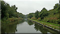
Birmingham Canal Navigations New Main Line near Smethwick
Looking north-west towards Wolverhampton from near the Smethwick New Pumphouse on a dull and drizzly day.
This is the Birmingham Canal Navigations New Main Line, engineered by Thomas Telford and mostly completed 1824-1827. Brindley's 1772 (lowered in 1790) old main line is at the top of an embankment on the right.
Image: © Roger Kidd
Taken: 26 Aug 2010
0.06 miles
10
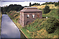
Brasshouse Lane Pumping Station
This was built to pump up from the new main line (left) to the summit level of the old main line (right). It replaced two beam engines closer to Birmingham. Restoration has since been completed, including a replica, non-functioning chimney.
Image: © Chris Allen
Taken: 29 Aug 1988
0.06 miles