IMAGES TAKEN NEAR TO
Brooklyn Avenue, BIRMINGHAM, B6 5BB
Introduction
This page details the photographs taken nearby to Brooklyn Avenue, B6 5BB by members of the Geograph project.
The Geograph project started in 2005 with the aim of publishing, organising and preserving representative images for every square kilometre of Great Britain, Ireland and the Isle of Man.

There are currently over 7.5m images from over14,400 individuals and you can help contribute to the project by visiting https://www.geograph.org.uk
Image Map
Images are licensed for reuse under creativecommons.org/licenses/by-sa/2.0
Notes
- Clicking on the map will re-center to the selected point.
- The higher the marker number, the further away the image location is from the centre of the postcode.
Image Listing (28 Images Found)
Images are licensed for reuse under creativecommons.org/licenses/by-sa/2.0
Image
Details
Distance
5
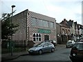
Aston Mosque and Community Centre
Jamia Mosque Ghausia in Albert Road.
Image: © Ian Rob
Taken: 14 Aug 2010
0.10 miles
6
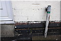
Benchmark on #200 Albert Road
Ordnance Survey cut mark benchmark described on the Bench Mark Database at http://www.bench-marks.org.uk/bm58186
Image: © Roger Templeman
Taken: 20 Dec 2014
0.14 miles
7
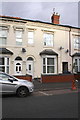
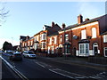
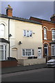
#200 Albert Road
There is an OS benchmark Image on the front of the house right of the door
Image: © Roger Templeman
Taken: 20 Dec 2014
0.14 miles
8
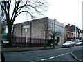
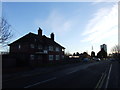
Mosque, Albert Road, Aston
On corner of Albert Road and Upper Sutton Street, Aston.
Image: © Michael Westley
Taken: 20 Mar 2010
0.15 miles
9
#156 Albert Road
The render applied to the front of the house has obliterated an Ordnance Survey benchmark levelled at 117.5m above mean sea level
Image: © Roger Templeman
Taken: 20 Dec 2014
0.15 miles
10
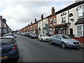
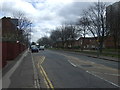
Frederick Road, Aston
19th century terraced housing in the middle of Brum; there's a lot of this around here.
Image: © Richard Law
Taken: 1 Feb 2017
0.18 miles