IMAGES TAKEN NEAR TO
Uplands Avenue, ROWLEY REGIS, B65 9PL
Introduction
This page details the photographs taken nearby to Uplands Avenue, B65 9PL by members of the Geograph project.
The Geograph project started in 2005 with the aim of publishing, organising and preserving representative images for every square kilometre of Great Britain, Ireland and the Isle of Man.

There are currently over 7.5m images from over14,400 individuals and you can help contribute to the project by visiting https://www.geograph.org.uk
Image Map
Images are licensed for reuse under creativecommons.org/licenses/by-sa/2.0
Notes
- Clicking on the map will re-center to the selected point.
- The higher the marker number, the further away the image location is from the centre of the postcode.
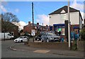
Image Listing (5 Images Found)
Images are licensed for reuse under creativecommons.org/licenses/by-sa/2.0
Image
Details
Distance
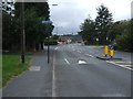
2
Blackheath Traffic Calming
The view in Throne Road.
Image: © Gordon Griffiths
Taken: 3 Sep 2010
0.23 miles
3
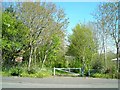
Footpath to Titford Pool
It often surprises me as I drive round Birmingham, how many of these inviting green walkways there are.
Image: © Antony Dixon
Taken: 22 Apr 2015
0.23 miles
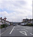
4
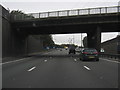
M5 Motorway - Northbound Near Junction 2
Image: © Peter Whatley
Taken: 5 Oct 2009
0.23 miles