IMAGES TAKEN NEAR TO
Greenwood Avenue, ROWLEY REGIS, B65 9NL
Introduction
This page details the photographs taken nearby to Greenwood Avenue, B65 9NL by members of the Geograph project.
The Geograph project started in 2005 with the aim of publishing, organising and preserving representative images for every square kilometre of Great Britain, Ireland and the Isle of Man.

There are currently over 7.5m images from over14,400 individuals and you can help contribute to the project by visiting https://www.geograph.org.uk
Image Map
Images are licensed for reuse under creativecommons.org/licenses/by-sa/2.0
Notes
- Clicking on the map will re-center to the selected point.
- The higher the marker number, the further away the image location is from the centre of the postcode.
Image Listing (2 Images Found)
Images are licensed for reuse under creativecommons.org/licenses/by-sa/2.0
Image
Details
Distance
1
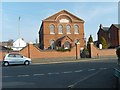
Providence Chapel
A church in Bell End road.
Image: © Gordon Griffiths
Taken: 8 Apr 2007
0.16 miles
2
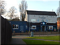
The Britannia, Rowley Regis
This pub in Rowley Village incorporates a micro-brewery at the rear.
Image: © Stephen McKay
Taken: 4 Jan 2020
0.24 miles