IMAGES TAKEN NEAR TO
Hailstone Close, ROWLEY REGIS, B65 8LN
Introduction
This page details the photographs taken nearby to Hailstone Close, B65 8LN by members of the Geograph project.
The Geograph project started in 2005 with the aim of publishing, organising and preserving representative images for every square kilometre of Great Britain, Ireland and the Isle of Man.

There are currently over 7.5m images from over14,400 individuals and you can help contribute to the project by visiting https://www.geograph.org.uk
Image Map
Images are licensed for reuse under creativecommons.org/licenses/by-sa/2.0
Notes
- Clicking on the map will re-center to the selected point.
- The higher the marker number, the further away the image location is from the centre of the postcode.
Image Listing (12 Images Found)
Images are licensed for reuse under creativecommons.org/licenses/by-sa/2.0
Image
Details
Distance
3
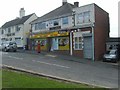
Knowle Post Office
The Springfield Office in Springfield Close next to the Hail Tone Pub off the B4171 in Rowley Regis.
Image: © Gordon Griffiths
Taken: 3 Sep 2010
0.22 miles
5
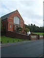
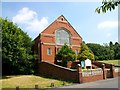
Dudley Road Church
The view of the Knowle Methodist Church in Rowley Regis.
Image: © Gordon Griffiths
Taken: 3 Sep 2010
0.22 miles
6
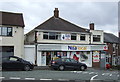
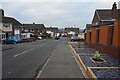
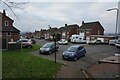
Post Office and shop on Springfield Close, Rowley Regis
Image: © JThomas
Taken: 22 Aug 2019
0.22 miles
8
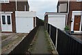
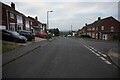
Path leading to Rough Hill Drive, Rowley Regis
Image: © Ian S
Taken: 17 Dec 2021
0.23 miles
10
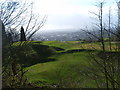
Dudley View
The view from Turner's Hill over the West Midlands.
Image: © Gordon Griffiths
Taken: 18 Mar 2007
0.24 miles