IMAGES TAKEN NEAR TO
Scotwell Close, ROWLEY REGIS, B65 8DF
Introduction
This page details the photographs taken nearby to Scotwell Close, B65 8DF by members of the Geograph project.
The Geograph project started in 2005 with the aim of publishing, organising and preserving representative images for every square kilometre of Great Britain, Ireland and the Isle of Man.

There are currently over 7.5m images from over14,400 individuals and you can help contribute to the project by visiting https://www.geograph.org.uk
Image Map
Images are licensed for reuse under creativecommons.org/licenses/by-sa/2.0
Notes
- Clicking on the map will re-center to the selected point.
- The higher the marker number, the further away the image location is from the centre of the postcode.
Image Listing (7 Images Found)
Images are licensed for reuse under creativecommons.org/licenses/by-sa/2.0
Image
Details
Distance
1
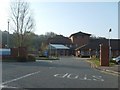
Rowley Regis Hospital
The entrance from Moor Lane.
Image: © Gordon Griffiths
Taken: 8 Apr 2007
0.16 miles
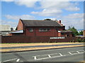
3
Hawes Lane, Rowley Regis
The road between Dudley and Blackheath, here called Hawes Lane.
Image: © David Weston
Taken: 15 Jul 2018
0.18 miles
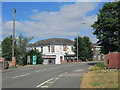
4
Hawes Lane and St Giles' Church Hall, Rowley Regis
The hall is across the road from the church.
Image: © David Weston
Taken: 15 Jul 2018
0.22 miles
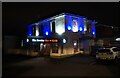
6
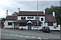
The Bulls Head, Rowley Regis
On Hawes Lane.
Showing position of Postbox No. B65 19.
See Image] for postbox.
Image: © JThomas
Taken: 22 Aug 2019
0.24 miles
7
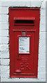
Elizabeth II postbox on the Hawes Lane, Rowley Regis
Postbox No. B65 19.
See Image] for context.
Image: © JThomas
Taken: 22 Aug 2019
0.24 miles