IMAGES TAKEN NEAR TO
High Street, ROWLEY REGIS, B65 0EB
Introduction
This page details the photographs taken nearby to High Street, B65 0EB by members of the Geograph project.
The Geograph project started in 2005 with the aim of publishing, organising and preserving representative images for every square kilometre of Great Britain, Ireland and the Isle of Man.

There are currently over 7.5m images from over14,400 individuals and you can help contribute to the project by visiting https://www.geograph.org.uk
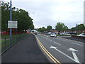
Image Map
Images are licensed for reuse under creativecommons.org/licenses/by-sa/2.0
Notes
- Clicking on the map will re-center to the selected point.
- The higher the marker number, the further away the image location is from the centre of the postcode.
Image Listing (22 Images Found)
Images are licensed for reuse under creativecommons.org/licenses/by-sa/2.0
Image
Details
Distance
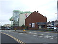
3
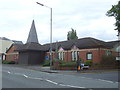
Black Country Housing Group
Black Country Housing Group is a registered social housing association based in Birmingham and the Black Country.
Image: © Stephen Rogerson
Taken: 8 Aug 2012
0.04 miles
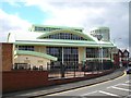
4
Kingsway International Christian Centre
Image: © Stephen Rogerson
Taken: 8 Aug 2012
0.05 miles
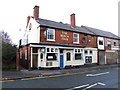
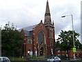
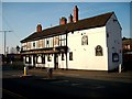
7
The Knights Quest
An interesting sign on the front of a pub by that name. http://www.theknightsquest.co.uk/
Image: © Stephen Rogerson
Taken: 8 Aug 2012
0.09 miles
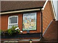
10
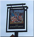
Sign for the Knights Quest, Rowley Regis
See Image] for context.
Image: © JThomas
Taken: 8 Jun 2019
0.11 miles