IMAGES TAKEN NEAR TO
Perry Park Road, CRADLEY HEATH, B64 6RP
Introduction
This page details the photographs taken nearby to Perry Park Road, B64 6RP by members of the Geograph project.
The Geograph project started in 2005 with the aim of publishing, organising and preserving representative images for every square kilometre of Great Britain, Ireland and the Isle of Man.

There are currently over 7.5m images from over14,400 individuals and you can help contribute to the project by visiting https://www.geograph.org.uk
Image Map
Images are licensed for reuse under creativecommons.org/licenses/by-sa/2.0
Notes
- Clicking on the map will re-center to the selected point.
- The higher the marker number, the further away the image location is from the centre of the postcode.
Image Listing (44 Images Found)
Images are licensed for reuse under creativecommons.org/licenses/by-sa/2.0
Image
Details
Distance
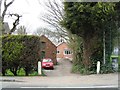
1
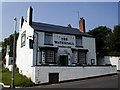
'The Wharf' public house - now derelict!
Since taking this picture the pub has been abandoned. The last time I passed it the roof was missing and it appeared to have had a major fire which seems to have totally destroyed the place. Update - was informed today 08 Aug' 2008 that this place no longer exists as it is now just a pile of rubble.
Image: © Row17
Taken: 1 May 2000
0.12 miles
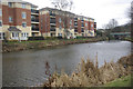
3
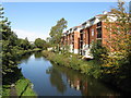
Modern Apartments by the Dudley Canal, Old Hill
Image: © Peter Whatley
Taken: 9 Oct 2008
0.13 miles
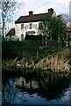
4
'The Waterfall' Public House
Although no longer a 'Freehouse' it does provide a variety of real ales' & is regularly mentioned in the Camra Real Ale Guide. A trickle of a natural waterfall is located in the garden.
Image: © Row17
Taken: 30 May 2002
0.14 miles
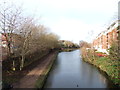
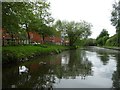
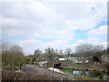
5
Dudley No 2 Canal, Old Hill
Not so long ago the view from urban canals tended to be of the backside of factories and other industrial sites. Nowadays, apartment blocks like these have become more common, developers seeing the waterside location as a major attraction. Not that the residents here will see much boating activity on this waterway which runs to a dead end at Halesowen; although there are extensive moorings at Hawne Basin this is really a canal for the dedicated enthusiast rather than the leisure boater.
Image: © Stephen McKay
Taken: 6 Feb 2011
0.14 miles
6
Houses in Kerewin Close
On the east bank of the Dudley No 2 Canal.
Image: © Christine Johnstone
Taken: 9 May 2018
0.14 miles
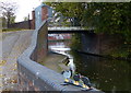
7
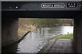
Wright's Bridge, Dudley no 2 Canal
Note the BCN (Birmingham Canal Navigations) date plate.
Image: © Stephen McKay
Taken: 6 Feb 2011
0.15 miles
9
Wright's Canal Bridge, Near Old Hill Station
Image: © Roy Hughes
Taken: 29 Mar 2013
0.15 miles