IMAGES TAKEN NEAR TO
Pearson Street, CRADLEY HEATH, B64 6EE
Introduction
This page details the photographs taken nearby to Pearson Street, B64 6EE by members of the Geograph project.
The Geograph project started in 2005 with the aim of publishing, organising and preserving representative images for every square kilometre of Great Britain, Ireland and the Isle of Man.

There are currently over 7.5m images from over14,400 individuals and you can help contribute to the project by visiting https://www.geograph.org.uk
Image Map
Images are licensed for reuse under creativecommons.org/licenses/by-sa/2.0
Notes
- Clicking on the map will re-center to the selected point.
- The higher the marker number, the further away the image location is from the centre of the postcode.
Image Listing (133 Images Found)
Images are licensed for reuse under creativecommons.org/licenses/by-sa/2.0
Image
Details
Distance
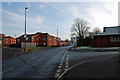
1
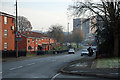
Lawrence Lane, Old Hill
View in the direction of Beechcroft Road.
Image: © Brian Clift
Taken: 29 Nov 2010
0.03 miles
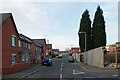
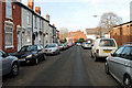
2
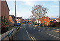
Pearson Street, Old Hill
View from Peartree Lane.
Image: © Brian Clift
Taken: 29 Nov 2010
0.03 miles
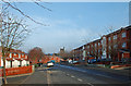
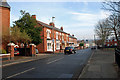
3
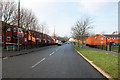
Lawrence Lane, Old Hill
View in the direction of Reddal Hill.
Image: © Brian Clift
Taken: 29 Nov 2010
0.04 miles
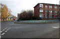
5
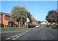
Lawrence Lane, Old Hill
At its junction with Clyde Street.
Image: © Brian Clift
Taken: 29 Nov 2010
0.06 miles
6
Petford Street, Old Hill
View from Peartree Lane.
Image: © Brian Clift
Taken: 29 Nov 2010
0.07 miles
7
Peartree Lane, Old Hill
View in the direction of Lawrence Lane.
Image: © Brian Clift
Taken: 29 Nov 2010
0.07 miles
8
Peartree Lane, Old Hill
At its junction with Beechcroft Road.
Image: © Brian Clift
Taken: 29 Nov 2010
0.07 miles
9
Church Street, Old Hill
View from Lawrence Lane.
Image: © Brian Clift
Taken: 29 Nov 2010
0.07 miles
10
Lawrence Lane, Old Hill
At the junction of Stacey Close.
Image: © Brian Clift
Taken: 29 Nov 2010
0.07 miles