IMAGES TAKEN NEAR TO
Hinton Fields, BROMSGROVE, B61 9HT
Introduction
This page details the photographs taken nearby to Hinton Fields, B61 9HT by members of the Geograph project.
The Geograph project started in 2005 with the aim of publishing, organising and preserving representative images for every square kilometre of Great Britain, Ireland and the Isle of Man.

There are currently over 7.5m images from over14,400 individuals and you can help contribute to the project by visiting https://www.geograph.org.uk
Image Map
Images are licensed for reuse under creativecommons.org/licenses/by-sa/2.0
Notes
- Clicking on the map will re-center to the selected point.
- The higher the marker number, the further away the image location is from the centre of the postcode.
Image Listing (18 Images Found)
Images are licensed for reuse under creativecommons.org/licenses/by-sa/2.0
Image
Details
Distance
1
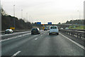
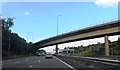
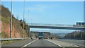
Junction 4A of the M5
The meeting of the M42 with the M5. The sliproad and the flyover are the northern spurs from the M42.
Image: © Bill Boaden
Taken: 27 Dec 2016
0.07 miles
2
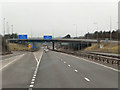
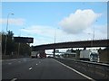
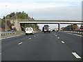
Southbound M5, Junction 4a (M5/M42 Interchange)
Image: © David Dixon
Taken: 1 Apr 2013
0.08 miles
7
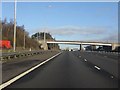
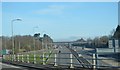
M5 Motorway - Rocky Lane overbridge, Catshill
Image: © Peter Whatley
Taken: 18 Jan 2011
0.14 miles
10
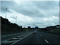
M5 At Catshill Summit
A minor summit at the point where the M42's west to north arm joins, prior to the final climb toward Frankley.
Image: © Peter Whatley
Taken: 28 Oct 2009
0.16 miles