IMAGES TAKEN NEAR TO
Woodland Road, BROMSGROVE, B61 9BS
Introduction
This page details the photographs taken nearby to Woodland Road, B61 9BS by members of the Geograph project.
The Geograph project started in 2005 with the aim of publishing, organising and preserving representative images for every square kilometre of Great Britain, Ireland and the Isle of Man.

There are currently over 7.5m images from over14,400 individuals and you can help contribute to the project by visiting https://www.geograph.org.uk
Image Map
Images are licensed for reuse under creativecommons.org/licenses/by-sa/2.0
Notes
- Clicking on the map will re-center to the selected point.
- The higher the marker number, the further away the image location is from the centre of the postcode.
Image Listing (8 Images Found)
Images are licensed for reuse under creativecommons.org/licenses/by-sa/2.0
Image
Details
Distance
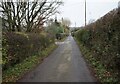
3
Woodland Road, Church Road junction Dodford
Image: © Roy Hughes
Taken: 14 May 2020
0.10 miles
4
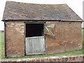
Stable at Rosedene
The stable stands next to Rosedene Cottage. From about the 1860s the Dodford strawberry crop was packed into boxes by the smallholders and taken in the small hours to Birmingham and Bromsgrove markets by horsedrawn cart.
Image: © Lorraine Wheale
Taken: 18 Apr 2010
0.17 miles
7
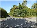
Crossroads in Dodford
The Monarch's Way passes down this road.
Image: © Philip Halling
Taken: 19 Sep 2017
0.20 miles