IMAGES TAKEN NEAR TO
Willow Close, BROMSGROVE, B61 8RF
Introduction
This page details the photographs taken nearby to Willow Close, B61 8RF by members of the Geograph project.
The Geograph project started in 2005 with the aim of publishing, organising and preserving representative images for every square kilometre of Great Britain, Ireland and the Isle of Man.

There are currently over 7.5m images from over14,400 individuals and you can help contribute to the project by visiting https://www.geograph.org.uk
Image Map (Loading...)


Getting Data...Please wait
Leaflet Map data © OpenStreetMap
Images are licensed for reuse under creativecommons.org/licenses/by-sa/2.0
Notes
- Clicking on the map will re-center to the selected point.
- The higher the marker number, the further away the image location is from the centre of the postcode.
Image Listing (179 Images Found)
Images are licensed for reuse under creativecommons.org/licenses/by-sa/2.0
Image
Details
Distance
1

Bromsgrove Unionist Club Limited (1), 18 Kidderminster Road, Bromsgrove, Worcs
Located on the corner of Kidderminster Road and Church Lane, with its entrance from the latter. The club was established in 1913 and is a member of the Association of Conservative Clubs Limited.
Image
Image: © P L Chadwick
Taken: 1 Jan 2016
0.05 miles
2

Church Lane, Bromsgrove, Worcs
Church Lane leads to Church Road, Crabtree Lane and Church Street.
Image: © P L Chadwick
Taken: 1 Jan 2016
0.05 miles
3

Bromsgrove Unionist Club Limited (2) - sign, 18 Kidderminster Road, Bromsgrove, Worcs
The sign is located on the corner of Kidderminster Road and Church Lane.
Image
Image: © P L Chadwick
Taken: 1 Jan 2016
0.06 miles
4

Kidderminster Road, Bromsgrove, Worcs
Part of the A448 road which, as the name suggests, goes to the town of Kidderminster. The wall-mounted postbox, on the right, dates from the reign of King George V (1910-1936). See:- Image
Image: © P L Chadwick
Taken: 1 Jan 2016
0.07 miles

6
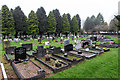
Bromsgrove Cemetery
The cemetery is in two parts either side of Church Road. This is the part west of Church Road.
Image: © David P Howard
Taken: 3 Apr 2014
0.07 miles
7

Footpath in the churchyard of St. John the Baptist, Bromsgrove, Worcs
The footpath leads down to Church Lane and Church Road, which is the road which can be seen straight ahead.
Image: © P L Chadwick
Taken: 1 Jan 2016
0.08 miles
8

Sanders Park Bromsgrove
Sanders Park Bromsgrove was created in 1968 on an area of rough pasture land that was left to the town by the Lucy Mary and Mary Beatrice Sanders - grand daughters of Ben Sanders, a local button maker and daughters of Benjamin Hadley Sanders, a former town clerk of the Urban District Council. It houses a "green man" 3-D sculpture and is the start and finish point for a number of way-marked local paths
Image: © Roy Hughes
Taken: 5 Jan 2009
0.08 miles
9
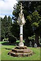
The John Adams Memorial Cross
The John Adams Memorial Cross in Bromsgrove cemetery. The memorial cross was designed as a tribute to John Adams in 1858 when the cemetery opened. John Adams was the largest employer in the town. The cross was removed in 2007 when it became dangerous and restored in 2013. John Adams was the great-great uncle of AE Housman, the Bromsgrove born poet best known for 'A Shropshire Lad'.
Image: © Philip Halling
Taken: 26 Apr 2018
0.09 miles
10
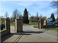
The main entrance to Sanders Park, Kidderminster Road, Bromsgrove, Worcs
The main entrance, with its gates, is off the A448 (Kidderminster Road). This is also the access to the car park.
Image
Image: © P L Chadwick
Taken: 7 Mar 2015
0.09 miles