IMAGES TAKEN NEAR TO
Swallows Close, BROMSGROVE, B61 0FP
Introduction
This page details the photographs taken nearby to Swallows Close, B61 0FP by members of the Geograph project.
The Geograph project started in 2005 with the aim of publishing, organising and preserving representative images for every square kilometre of Great Britain, Ireland and the Isle of Man.

There are currently over 7.5m images from over14,400 individuals and you can help contribute to the project by visiting https://www.geograph.org.uk
Image Map
Images are licensed for reuse under creativecommons.org/licenses/by-sa/2.0
Notes
- Clicking on the map will re-center to the selected point.
- The higher the marker number, the further away the image location is from the centre of the postcode.
Image Listing (17 Images Found)
Images are licensed for reuse under creativecommons.org/licenses/by-sa/2.0
Image
Details
Distance
1
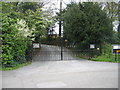
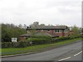
Gates to the former Mount School
The Mount School was situated at the junction of the Birmingham Road and the Bromsgrove bypass. It was an Independent Non Denominational Primary School and operated from 1957 to 2004. The premises were then used by the safety training company KeyOstas, part of whose name sign can be seen at the right-hand edge of the image.
Image: © David Stowell
Taken: 30 Apr 2006
0.02 miles
2
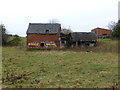
Derelict farm buildings
In 2014, someone decided to "decorate" this old derelict building. See Image for it some years before.
Image: © Mike Dodman
Taken: 8 Jan 2014
0.02 miles
3
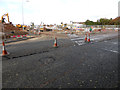
New housing development on site of old farm buildings
In 2016, the old derelict buildings (in a field alongside the Birmingham Road leading north out of Bromsgrove town centre) were finally bulldozed to make way for new housing. See Image and Image for the old buildings.
Image: © Mike Dodman
Taken: 12 Oct 2016
0.02 miles
5
Townend Veterinary Practice
A recently much enlarged clinic at the junction with the Bromsgrove Bypass.
Image: © David Stowell
Taken: 30 Apr 2006
0.06 miles
6
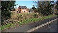
Derelict farm buildings
I've lived in Bromsgrove since the mid 70's and I recall these being derelict then!
Image: © Mike Dodman
Taken: 8 Mar 2009
0.06 miles
7
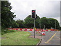
Birmingham Road Bromsgrove Closed Southbound
Image: © Roy Hughes
Taken: 18 Jun 2016
0.06 miles
8
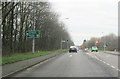
Birmingham Road junction with A38
Looking south on the A38, Birmingham Road is to the left at the traffic lights
Image: © John Firth
Taken: 27 Dec 2011
0.07 miles
9
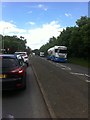
Stopped traffic, A38 at the Birmingham Road junction
Image: © Darrin Antrobus
Taken: 10 Jun 2014
0.08 miles
10
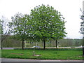
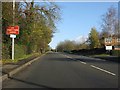
Bromsgrove bypass road junction
A chestnut showing that spring is in the air at the junction of Bromsgrove bypass with the Birmingham Road, Bromsgrove.
Image: © David Stowell
Taken: 30 Apr 2006
0.08 miles