IMAGES TAKEN NEAR TO
Birmingham Road, BROMSGROVE, B61 0DH
Introduction
This page details the photographs taken nearby to Birmingham Road, B61 0DH by members of the Geograph project.
The Geograph project started in 2005 with the aim of publishing, organising and preserving representative images for every square kilometre of Great Britain, Ireland and the Isle of Man.

There are currently over 7.5m images from over14,400 individuals and you can help contribute to the project by visiting https://www.geograph.org.uk
Image Map
Images are licensed for reuse under creativecommons.org/licenses/by-sa/2.0
Notes
- Clicking on the map will re-center to the selected point.
- The higher the marker number, the further away the image location is from the centre of the postcode.
Image Listing (35 Images Found)
Images are licensed for reuse under creativecommons.org/licenses/by-sa/2.0
Image
Details
Distance
1
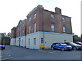
Former hospital building, Bromsgrove
This was an older part of Bromsgrove General Hospital, the larger part of which was about WWII vintage. The hospital has now been relocated and this building is in multiple occupancy.
Image: © Chris Allen
Taken: 20 Aug 2019
0.04 miles
2
Former hospital building, Bromsgrove
This was an older part of Bromsgrove General Hospital, the larger part of which was about WWII vintage. The hospital has now been relocated and this building is in multiple occupancy.
Image: © Chris Allen
Taken: 20 Aug 2019
0.04 miles
3
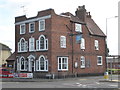
Crabmill Inn, Bromsgrove
I think I had an occasional drink here before or after evening postgraduate meetings at the then Bromsgrove General Hospital. It was moved to Redditch in the 1980s so it is a long time ago.
Image: © Chris Allen
Taken: 20 Aug 2019
0.04 miles
4
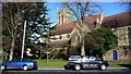
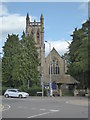
All Saints parish church.
As viewed from Burcut Lane, in front of Bromsgrove District Council offices.
Image: © Mike Dodman
Taken: 8 Mar 2009
0.08 miles
5
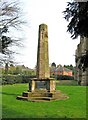
War Memorial near Birmingham Road
The memorial, which appears to date from just after the First World War (1914-1918), is sadly showing some signs of decay. It can be found in the grounds of All Saints Parish Church, near to Birmingham Road.
Image: © P L Chadwick
Taken: 10 Apr 2010
0.09 miles
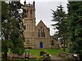
6
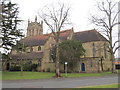
All saints Church, Bromsgrove
The church was built: 1872 (tower 1880);Architect: John Cotton
Image: © Richard Rogerson
Taken: 16 Feb 2013
0.09 miles
7
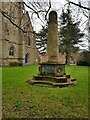
War Memorial at All Saints, Bromsgrove, Worcestershire
Image: © Jeff Gogarty
Taken: 5 Mar 2021
0.09 miles
8
All Saints Church, Birmingham Road, Bromsgrove
The footbridge in the foreground is over Spadesbourne Brook.
See https://historicengland.org.uk/listing/the-list/list-entry/1100370 for listing status.
Image: © Jeff Gogarty
Taken: 5 Mar 2021
0.09 miles
9

All Saints Parish Church
Located on the corner of Birmingham Road and Burcot Lane. The church is Victorian, dating from 1872-74, but the tower was added in 1887-88. The spire was never built.
Image: © P L Chadwick
Taken: 10 Apr 2010
0.09 miles