IMAGES TAKEN NEAR TO
Norris Close, BROMSGROVE, B60 3SJ
Introduction
This page details the photographs taken nearby to Norris Close, B60 3SJ by members of the Geograph project.
The Geograph project started in 2005 with the aim of publishing, organising and preserving representative images for every square kilometre of Great Britain, Ireland and the Isle of Man.

There are currently over 7.5m images from over14,400 individuals and you can help contribute to the project by visiting https://www.geograph.org.uk
Image Map
Images are licensed for reuse under creativecommons.org/licenses/by-sa/2.0
Notes
- Clicking on the map will re-center to the selected point.
- The higher the marker number, the further away the image location is from the centre of the postcode.
Image Listing (132 Images Found)
Images are licensed for reuse under creativecommons.org/licenses/by-sa/2.0
Image
Details
Distance
1
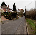
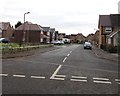
End of the pavement, St Godwald's Road, Bromsgrove
Ahead, the pavement ends and the road narrows.
Image: © Jaggery
Taken: 3 Dec 2016
0.02 miles
2
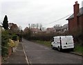
Independent Fire Protection van, St Godwald's Road, Bromsgrove
The white van is parked near the corner of Rutherford Road.
Independent Fire Protection is based in Goosemoor Lane, Birmingham.
Image: © Jaggery
Taken: 3 Dec 2016
0.04 miles
3
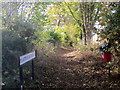
Platform Road Footpath Finstall Bromsgrove
Image: © Roy Hughes
Taken: 5 Nov 2016
0.04 miles
4
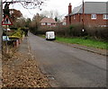
Warning sign - pedestrians, St Godwald's Road, Bromsgrove
Walkers may be in the road because the pavement ends beyond the van ahead.
Image: © Jaggery
Taken: 3 Dec 2016
0.06 miles
5
Rutherford Road, Bromsgrove
Viewed across St Godwald's Road.
Image: © Jaggery
Taken: 3 Dec 2016
0.07 miles
6
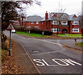
Warning sign - road narrows, St Godwald's Road, Bromsgrove
The warning sign and the SLOW painted on the road surface are on the approach to this http://www.geograph.org.uk/photo/5214329
narrower part of the road. The Rutherford Road http://www.geograph.org.uk/photo/5214327 junction is on the right.
Image: © Jaggery
Taken: 3 Dec 2016
0.08 miles
8
St. Godwald's Road, Bromsgrove, Worcs
A road on the edge of the Aston Fields area of Bromsgrove.
Image: © P L Chadwick
Taken: 1 Jan 2016
0.13 miles
9
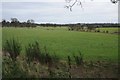
Finstall Park
Finstall Park at Aston Fields on the edge of Bromsgrove.
Image: © Philip Halling
Taken: 19 Feb 2016
0.15 miles
10
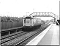
Diesel Multiple Unit at Bromsgrove, 1990
Single car diesel multiple unit No M55034 calls at Bromsgrove Station on a Barnt Green to Worcester service in the autumn of 1990.
Image: © Rob Newman
Taken: 2 Oct 1990
0.15 miles